viernes, 28 de marzo de 2014

Charcas de Erjos


Municipio: El Tanque
Duración aproximada: 2 horas
Altura Máxima:1187 metros (desde nivel del mar)
Altura Mínima: 1020 metros (desde nivel del mar)
Distancia (KM): 2,87 Km (ida)


Descripción de la zona


Nos encontramos dentro del Parque Rural de Teno. El Paraje de los Dornajos “Charcas de Erjos”, fueron extracciones de áridos y tierra entre los años 70 y 80 del siglo XX para ser trasladados a las plantaciones del sur y norte de la isla. Por su carácter arcilloso se han transformado en depósitos naturales de agua de lluvia. Ello las convierte en una de las escasas zonas de interior capaces de albergar especies acuáticas.

Finalizadas las extracciones, hace alrededor de 20 años, gran cantidad de especies vegetales y animales han ido colonizando paulatinamente las charcas, aunque su presencia está condicionada por las lluvias, por lo que las charcas pueden permanecer semisecas durante largos periodos de tiempo.

En estas charcas la especie vegetal de mayor porte es el sauce canario (Salix canariensis) existiendo otras como los tabacos (Typha domingensis), los juncos (Juncus efussus) y los carrizos (Cyperus eragrostis). También helechos, zarzas, tagasastes, etc

Una de las Charcas
Pero sin duda alguna, las más espectaculares protagonistas de las charcas es la fauna, en concreto las aves ligadas al medio acuático. Entre ellas destacan la gallineta común (Gallinuela chloropus), cuya presencia se constata desde los años 80, la focha común (Fulica atra), la agachadiza común (Gallinago gallinago) y la garza real (Ardea cinerea). Otras aves relacionadas con el medio acuático que suelen avistarse de forma más irregular son la alpispa o lavandera cascadeña (Motacilla cinerea canariensis), el archibebe claro (Tringa nebularia) y el guincho o águila pescadora (Pandion haliaetus) que se puede ver en algunas ocasiones, sobre todo cuando el mal estado del mar dificulta la búsqueda de alimento.

Cabe resaltar, que las charcas son además paso obligado de las aves migratorias, que se encuentran en nuestras tierras un lugar idóneo donde pasar los crudos inviernos del norte de Europa.

Descripción del sendero

Elevación Charcas de Erjos
Elevación Cumbre Bolico

Antes de explicar el recorrido, decir que en el mapa, la ruta verde discurre a través de las charcas, y la ruta roja va hacia Cumbre el Bolico.

Comenzamos la ruta en la entrada que se encuentra enfrente del bar (un bar solitario en todo ese tramo de carretera que conecta con Santiago del Teide, al lado de mismo se encuentra una parada de guagua, línea 360 (desde Icod hasta Puerto de Erjos). El trato con nosotros fue de antipáticos). Para llegar al mismo, se puede llegar con transporte público y con coche propio. El aparcamiento es escaso, pero hay zonas de la carretera donde esta se ensancha y se puede dejar. (El aparcamiento del bar, es exclusivo de estos, aunque deja aparcar a quién ellos quieran).

El sendero se encuentra parcialmente señalizado, ya que en las mismas charcas se puede tomar varias rutas de senderos y apreciarlas desde diferentes puntos de vista. Aunque no tiene perdida, ya que el camino se encuentra bien delimitado.

En este caso hicimos la ruta que conecta con el sendero del Monte del Agua y retrocedimos hacia las misma.

Inicio del sendero

Luego cogimos el sendero que va a dar a la Cumbre Bolico, donde se puede ver el conjunto de las charcas con el Teide de fondo. Al finalizar este sendero en ascensión continua, llegamos al lugar desde donde podemos apreciar Santiago del Teide. 

Al finalizar salimos por el mismo sitio, ya que la vuelta fue por la misma ruta.

La ruta de las Charcas se puede hacer sólo visitando las mismas, o se puede acceder a través de varios senderos que pasan por la zona.

En esta ocasión las charcas estaban bastante llenas, ya que las lluvias durante gran parte del invierno han sido abundantes. En cuanto a la vegetación estaba algo escasa, ya que todavía la zona se esta recuperando del incendio acaecido en 2012.

Vista de las Charcas, por el sendero que conecta a Cumbre el Bolico.


viernes, 21 de marzo de 2014

Chanajiga (Chanajiga Path)


Municipality: Los Realejos
Aproximate time: 4:30h
Maximum Height:1350m (aprox)    
Minimun Height: 1100m (apox)
Distance (Km): 9,3km


Area Information


To come to this site, we must cross in entirety the municipality of  Los Realejos, since it is in the high zone of the same one. It is a Caldera (Great volcanic depression in more or less circular form). However we call by that name for a recreative area, where we can find ovens, tables and banks, swings, etc. Nevertheless on the island we have some Calderas and at the same time are places of scattering. (This way of calling Caldera in a recreative area is more extended in the north of the island, that in the south. 

Path (at the beginning)
This path passes on the part of the La Corona Forestal (It is a wooded mass about the national park of the Teide), so we are walking through an area protected from 1987. With 50.000 hectares, It includes the municipalities of  Los Realejos, Adeje, Vilaflor, Guía de Isora, Santiago del Teide, Garachico, Icod de los Vinos, La Orotava, La Guancha, San Juan de la Rambla, Granadilla, Arico, Fasnia, El Tanque, Güímar, Arafo y Candelaria. 

This is a really important due to the fact that it exercises an emphasized paper in the capture of waters and the conservation of soils before the erosion.

El Pino Canario ( The Canary pines)  is the best example of the vegetation of the zone. Also we find green mound that remains constituted by the forest of laurisilva and fayal-brezal. It is also finding some endemic species like the bejeque, the chahorra, the marzagana, etc.

The fauna are tied to the pine, for what the best example that we find is the pinzón azul (is is a kind of bird). There are also other flying species as the bat and the moth. As for species of major size we find the muflón (like a sheep) and the rabbit, that they were introduced  in the zone

Vegetation
The ravines, pythons, washes and recent lava are the most representative geomorphologic elements.

As for the history, the original inhabitants of Tenerife were living on the zone, because it was found some archaeological remains in the diverse natural caves. After the conquest, the zone suffered an intense deforestation, because the wood was an important element for the houses, ceilings, ships, etc, from that it was used on the island and a great part was exported. After the big hurts caused by this deforestation, the La Corona Forestal was afforested, for that  the endemic species are so narrow.  

Description of the path

The drop of the Path
We begin the tour leaving the vehicles in the parking zone of Chajiga, we can also take the bus line 347 (from La Orotava, it passes through the upper part of town, but does not reach la caldera). From there we start walking and rightly to the height of the swings we find the signs of a path. We did the tour of the forest road, for what with a few meters of these signs we find the sign of wrong path. Nevertheless, we cross this sense, to go towards El Pino Llorón (Weeping Pine)

In this section we do not find signs of the path, however we find some of the paths that connect with this road and pass across it. On having walked almost along the half of the tour, we find a table with banks, where it is possible to re-put forces and enjoy the sight of the Valley.

Valle de La Orotava
We come to a crossing, where it is possible to take for the antenna of TV, or continue in the way that ascends. It is at this point where there is a Pino Llorón (Weeping Pine) (it calls this way since  when it is cloudy it catches the water of the clouds).

We continue in the ascending way, and take the first entry to the left side that we see, to few meters one finds a house (if we were not turning aside, we would continue in the path that is going to give to Las Cañadas del Teide,  exactly to the zone of el Cabezón (Pigheaded)).Continuing in this way, that there are signs, it is easy to continue (if it is not left) since it is a forest road. Along this tour, we go on from leafy zones to more uninhabited zones of vegetation. Also we will cross with signs of other paths, and again with the one that puts up signs as Cañadas.

Some signs
On having finished this section, we come to the forest road that connects with La Caldera de la Orotava 
(Orotava´s boiler). In this crossing we come to a shed and take the signposting of Chanajiga. At the end of this way, we come to the boiler, just to the point where the autos were left, the point of the beginning.

Along the tour, we come through for zones of mud (if it has rained previously), zones in which it is possible to see the valley, Izaña, zones full of vegetation, zones where the vegetation is cut, etc.

We continue in the ascending way, and take the first entry to the left side that we see, to few meters one finds a house. We follow for this way, that though not this one put up signs, it is easy to continue if it is not left. At the end of the same one, we come to a shed, where there appears the sign of another way, to go up to the boiler of the Orotava, but we take to the left side

It is suitable to do it in a cleared day and cloudily, though this second prevents from seeing the valley, nevertheless if in half of the tour it is started clouding, is a spectacle to see the movement of the clouds for all this zone, since they are ascending.

We only have done a small tour inside La Corona Forestal, inside the same one, there are a multitude of paths.

La Palma


martes, 25 de febrero de 2014

El Tanque


Municipality: El Tanque

History


In the 16th century, an important number of colonists were residing in that municipality. The growth of the municipality was slow due to the orography of the area (area with high slopes and malpaíses (accident relief characterized by the presence of weathered volcanic rocks in an arid environment )), that was impeding the development of the agriculture. But it did not prevent that there was an important number of cultivations, which needed some way for its irrigation and with this intention, a small reservoir is constructed. In the proximities of the same one, there arose numerous housings, which at the time would meet place in the urban core of El tanque (it means watertight, and the name of the municipality is due to its construction) , emphasizing the construction of the hermitage of San Antonio in 1540.

The increase of the prices of the wheat and the barley, due to the to the increase of the lands dedicated to the cultivation of the vineyard, this fact did that the conditions of the population were hardening. 

Era (circle made for thresh wheat)
During these centuries, the region suffers a series of calamities ( infect of lobster, bad crops, droughts) that complicates much more the economic existing situation.

In the 17th century and the XVIIIth, the situation did not improve. Before the fall of the trade of the wine, the lands devote themselves to the cultivation of cereals (wheat and maize) and potato for a self-consuming (in the main).

The population was marked by the emigration, supposing the loss of important workforce. This owes, apart from the plagues before mentioned and the crises, to the eruption of 1706, moment in the one that began the building of the El Tanque Alto (population core).  

El Tanque

Representative Buildings


Parroquia de San Antonio de Padua (Sant Antonio´s Church): it was declared BIC in 2011. It was constructed as a hermitage in 1540, with a ship and major chapel. In 1668 the sacristy and the ossuary were constructed in 1678. The belfry was reached in 1679, whereas the Calvary and the way in 1698. Though the choir of wood was bought, it was in steps of being placed just before the eruption. In 1706 the temple remained satiny, but the images were moved  to the Public granary and el Santo (The Saint) was trasladeted to la Parroquia de Nuestra Señora de la Luz, in Los Silos. For the new construction it was thought about the former layout. Due to the penuries of the zone, the works did not conclude until 1770. During the 60s of last century, the tower was modified.

In the interior stands out the major altarpiece of two bodies with attic. We can  find Nuestra Señora del Buen Viaje ( Our Lady of the Good Trip), San Miguel Arcángel (San Miguel Archangel) y San Antonio de Padua, being three heights of the 16th century. Other representations that we can find are Cristo Crucificado (Christ Crucify),  la Dolorosa (The Painful),  San Juan Evangelista (San Juan Evangelist) , Santa Elena (Holy Elena), all of them images between the XVIIth and XVIIIth century.


San Antonio´s Church
The Watertight: nowadays we can find only some primitive walls stay of what it gave origin to the municipality.

The Watertight

La Casa de los Marteles (The house of the Marteles):  it was declared BIC in 2011. This house dated in the 17th century and it did not suffer hurts derived from the eruption of 1706. In the front one finds a small central balcony of board on girders. The principal door and one of the windows are protected windows by an alpende (cover with demolished supported by columns, as a portico) by cover of tile. Nowadays it is in ruins, but nonetheless it possesses the captivation of the times in those that it was constructed.


Los Marteles´s Hause


La Alhóndiga (The Public granary):  it was declared BIC in 2011. It possesses two floors with windows and doors without symmetry, it was the authentic center of the socio-political life of the locality. It was a place destined to guard the cereals, then to be distributed between the neighbors in times of bad crops. Nowadays it is reformed. 

One door of the granary

The real estate that we have named, is in the El Tanque, the first core of the municipality of  El tanque. Nevertheless along all this municipality real estate can be visited by the same characteristics as  La Casa de los Guzmanez (The House of the Guzmanes),  La Casa de los Viudos in El Tanque Alto, Las Eras del Volcán (circle made for thresh wheat) and las Eras de Franquis, etc.

Mirador de la Atalaya (Veranda)

martes, 18 de febrero de 2014

Teno Alto (Teno Alto Path)


 Municipality: Buenavista del Norte
Aproximate Time: 5 Hours
Minimum Height: 984m
Maximum Height: 508 m
Distance (Km):10,4


Area Information

It is a rural space, which together with Macizo de Anaga (Anaga's Clump), both are the only rural spaces of the island. This type of cataloguing owes to that in this zone where coexists agricultural activity with places of special natural and ecological interest. This type of protection wants to protect this human activity and the ecology of the zone.

Path and the end Masca´s street

El parque Rural de Teno (Teno's rural park) is distributed between  the municipalities of Buenavista, LosSilos, El Tanque and Santiago del Teide, though the majority of the surface and the population who resides are in the municipality of  Buenavista. This population is distributed between the hamlets of  El Palmar, Las Portelas, Teno Alto, Los Carrizales and Masca.

The principal activity in the zone continues to be the agriculture, though nowadays service is realized of joint form by the sector, due to the facth that the visitor's appearance that consume and buy the products of the zone. As for the hamlets, we continue being Canary houses, though modern housings have proliferated in the last years.

The vegetation that one finds in the different zone according to the altitude, being in the high zone the forest of laurisilva. As for the fauna, we find diverse endemic species, since they are la paloma de la laurisilva (dove), el águila pescadora ( fish eagle), lagarto gigante de teno (giant lizard of teno), etc. On having been numerous ravines and abrupt cliffs exist.

Description of the Path


The drop of the Path


To initiate the path, the point of item is the visitors' center of Teno's Rural Park, in the village of El Palmar, the place where it is possible to buy local products on the market of the farmer. In the zone it is possible to accede with public transport, bus line 366 (from Buenavista to El Palmar) and line 355 (from Buenavista through Masca)  and own cars. 

On having initiated the way, we have to walk a few meters from this village. After  a few meters from the point of beginning we find  the first curve where it is a track the right hand, of cement. Here the ascension of the path is begun, where the first section passes on cement, then to continue in a way covered by vegetation. In the same way, we must take the first crossing to the right, being on a curve. Following the ascension, we take for the first door that we find, put to prevent the traffic of vehicles. On having come at a height of the house, we find a sign of a path, only one in all this tour. Finally, after crossing the hillside, we come to the viewing-point. A point in which some hamlets and La Gomera are spied, and also the way begin to come to the village of Teno Alto.


Overlooking La Gomera

This part of the tour is put up signs, and we put to circulate across these hillsides. This zone is depopulated of vegetation, though we can find some redoubts that cover the walker. The path is flat, though we meet some earring. On having finished this section, we go past  for a redoubt of laurisilva.

Coming to the proximities of the village, it is started observing the signposting  that  takes us up to Teno's hamlet. Once at this location, the famous cheeses of the zone can be tasted, and see some houses of traditional typology, with some of construction more modern.

To finish we take the path that goes towards El Palmar. In this path, we find thick vegetation and alternation of earrings and descents.A point of reference are the towers of light, a point for which the way that stays is in continuous decrease, just walking very close to the Street. The way is paved, being difficult his decrease in rainy days, due to the smooth thing that the rocks are.

Path

Finishing this section, we find a recreational area  and come right to the point of its initiates, the same road that comes to the visitors' center.

It is necessary to bear in mind, that the path is put up signs in the zone previous and later to the village of Teno Alto. We have done three paths in one, since it was a good option to create it of circular form.

The paths put up signs by that we pass are those who give of the viewing-point Teno Alto and the one that goes down the village of El Palmar. The first section, it is not put up signs as the others, having special precaution at the moment of walking in the last part of the same one.  The greater part of the tour must be done in a single line for the reduction of the same one.

El Palmar


domingo, 16 de febrero de 2014

Almendros en Flor (Almond-trees in flower)


Municipaltity: Santiago del Teide
Aproximate Time: 5 hours
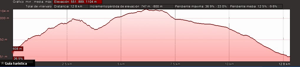
Maximun Height: 104 m (aprox)
Minimun Height: 51 m (aprox)
Distance (KM): 12,8


Area Information


We are in the Municipality of Santiago del Teide, in the Southwest of the Island. This time we realize this route to visit the event of Almendros en Flor (flowering of the almonds) that takes place between the months in January to February (being able to doubt more or less), due to the fact of the zone and the climatology that has developed.

The almond-trees (introduced in the island) are trees of expired leaf, which can have between 3 and 5 meters of height, with a thin figure that possesses colors between green, yellow, and be more cracked according to the age of the tree. The flowers possess colors between white and pink.

Almond-trees

The flora that prevail all the year are fig trees, sabinas (originally from the islands), brooms, pine tree, bushes, etc. Between the fauna of the zone, we find lizards, ants and diverse birds.

Description of the Path

The drop of the path


We can realize the tour in several ways, since there are different routes that we can choose to come to the zone of Santiago del Teide where the great majority of the almond-trees are located. We have chosen a route of an only one felt across the almond-trees, for what we go out of  population of  Tamaimo, and it is to this one where we return.

In the zone it is possible to enter in car and in public transport, line 462 (from Guía de Isora), 355 (from Buenavista to Valle Santiago). This one has several lines and schedules depending on the step in which this way of transport is taken. If the car is chosen, there is parking along the whole village.

Teide

We go out of  from Tamaimo going through the Camino Real (streets that were built during the XVII century to connect different villages) to Arguayo. Across these ways, which partly it possesses the original stone pavement one does not find any signposting of paths. Passing Arguayo we continue for these paths and arrive to Las Manchas.

Between Las Manchas and Santiago del Teide, we find the major quantity of almond-trees and it is in this part where it is possible to see some of the signposts owning the fact that in that point there are several paths which go across.

Path between Arguayo and Las Manchas

The way is well-defined, and we walk for the volcanic wasch and in others where the land has been saturated for the plantations and the soil is softer at the moment of trading.

Path going to Santiago del Teide

On having finished the path we come to the hulk of Santiago del Teide, being able to enjoy the food in the different bars and restaurants, and  it is possible to relax in the recreative park, where are tables, chair, grills and swings.

We finish the same one in Tamaimo, taking the former royal one that was joining both villages.

Almond-trees


lunes, 10 de febrero de 2014

Almendros en Flor


Municipio: Santiago del Teide
Duración Aproximada del Recorrido: 5 horas
Altura Máxima:  104 m (apox)
Altura Mínima: 51 m (aprox)
Distancia (KM): 12,8


Información Sobre la Zona


Nos encontramos en al Municipio de Santiago del Teide, en el Suroeste de la Isla. Esta vez realizamos esta ruta para visitar el acontecimiento de la floración de los almendros que tiene lugar entre los meses enero a febrero (pudiendo durar mas o menos), según en que zona y la climatología que se haya desarrollado. 

Los almendros (introducidos en la isla) son árboles de hoja caduca, que pueden tener entre 3 y 5 metros de altura, con un talle delgado que posee colores entre verde, amarillo, y estar mas agrietado según la edad del árbol. Las flores poseen colores entre blanco y rosado.

Almendro en Flor

En cuanto a la flora que predomina durante todo el año y que también podemos disfrutar de estos meses del florecimiento encontramos higueras, sabinas, retamas, pinar, matorral, etc. Entre la fauna de la zona, encontramos lagartos, hormigas y diversas aves.

Descripción del Recorrido


Recorrido y Mapa de Elevación

El recorrido se puede realizar de varias maneras, ya que hay diferentes rutas que escoger para llegar a la zona donde se ubica la ruta más conocida de los almendros, en este caso es en el casco de Santigado del Teide. Nosotros hemos escogido una ruta de un único sentido a través de los almendros, por lo que salimos de núcleo población de Taimo, y es a este mismo donde regresamos.

A la zona se puede acceder en coche y en transporte público, líneas 462 (desde Guía de Isora), 355 (Buenavista hasta Valle Santiago). Este tiene varias lineas y horarios dependiendo de la parada en la que se coja este medio de transporte. Si se elige el coche, hay aparcamiento a lo largo de todo el casco.

Vistas a diferentes núcleos de Santiago del Teide, el último arriba es el Casco de Santiago de Teide.

Salimos de Tamaimo pasando por el antiguo camino real que lo unía con Arguayo. A través de estos caminos, los cuales en parte posee el empedrado original  no se encuentra ninguna señalización de sendero. Siguiendo por este sendero, llegamos al nucleo de Las Manchas.

Camino que une Arguayo y Las Manchas

Entre Las Manchas y Santiago del Teide encontramos la mayor cantidad de almendros y es en esta parte donde se puede ver algunas de las señalizaciones, ya que a través del mismo discurren algunos senderos.

El camino se encuentra bien definido, pasando por parte de colada volcánica, y en otros donde la tierra ha sido saturada para la plantación de cultivos y el suelo es más suave a la hora de pisar.

Sendero hacia Santiago del Teide


Al terminar el sendero llegamos al núcleo y casco de Santiago, pudiendo disfrutar de su comida en los diferentes bares y restaurantes y en el parque recreativo.


Nosotros finalizamos el mismo en Tamaimo, cogiendo el antiguo real que unía ambos núcleos.


Almendros en Flor


domingo, 2 de febrero de 2014

Puerto de la Cruz

Municipality: Puerto de la Cruz

History


We cannot speak about the history of El Puerto de la Cruz, without speaking about the tourism, since these two words are related , and this municipality is the symbol of the tourism in Tenerife. Though  more destinations exist on the island, which to see and to enjoy, the tourist was originated in this municipality, and on the Canary Islands. But it is necessary to see the history of that place before, until the tourism arrived. 

The Conquest of the Island finished in 1496, being established La Laguna as the capital of the island. The rest of the island was divided into several Comarcas (areas). These areas were divided as The Menceyatos were. So, the actual municipalities of La Orotava, Puerto de la Cruz and Los Realejos were named Comarca de Taoro (Taoro´s area). This area accounted jurisdiction of La Orotava, in whose littoral was ordained to construct a wharf. It was the year 1506 when it started to establish a poor village known as Puerto de la Orotava.

In the 17th century it was established the first hearth of the zone, which was running from  Castillo San Felipe (San Felipe´z castle) to Santa Barbara, extended towards Martiánez. Since that was started putting up signs on the sites, making a Church with its square and it was started to fortify the area due to the fact pirates and corsair attacks were frequent. 


El Peñón

Due to the increase of the population in the zone, in 1648 the King Philip IV dictated a Royal Bond in the one that was giving herself the emancipation to the Port of the Orotava, but I do not come into force until 1651, and it was finally in 1172 when the zone I achieve the independence.

The destruction of Garachico's port in 1706 turned to Puerto de la Cruz in the principal port of the Island  this moment was  the most important epoch of the history of the City, from the points of view economically, socially and culturally. The zone that first was dedicated to the sugar cane, then it was developed the cultivation of the wine.

It was at the end of the 19th century when  the first "tippers" visited the City. They were from Great Britain and  were coming to the Island on board of the steams of the fruit companies. It was  at the time when " there was discovered " the kindness of the spring climate and the beauty of the landscape, which were  the principal reasons that were rewarding the long Atlantic voyage. Scientific (those who were studying the geography of the island) and doctor ( they were studying the kindness of the time, for possible priests as the tuberculosis) and affluent people arrived to the island.  Many luxury cruises which went to other places stopped on the island and it was possible to do excursions, for what the City was laying the foundations of what at least would turn into its economic engine.

The strategic situation and agreeable climate, attracted merchants of several nationalities who were turned into the bourgeois dominant class.

Marqueza Hotel


In the whole Europe there was spread a sanitary publicity, across a multitude of articles in press, guides and leaflets. The important fruit companies that were operating in Canaries were used as tourist lines. The shipping ones started taking part in the tourist business. They were called tourist - fruit cruises. The agencies conscious of the importance of the incipient tourist movement, strained also in promoting Tenerife. At this moment, Puerto de la Cruz began the decadence as a commercial center, it was due to the crises of the export of the wine,  later, of the cochineal (a small animal who grow up in tunera (a species of cactus)) and for the development of the port of Santa Cruz, with having better natural conditions

On the island , it was warned also the periodic visits of foreing people whose visits could be an important source of income. The privileged climate and the landscape where a strong claim. The British presence, especially, was decisive for the beginning of the tourist industry in Puerto de la Cruz and El Valle de la Orotava.


Representative Buildings

Though Puerto de la Cruz is not the same place as years ago, just as the first period of the tourism, still it is and must be an obligatory step to understand the evolution of the population, who form being farmers to being employed in the tourist sector. For it we are going to name some of the nicest real estate of this zone.


Muelle Pesquero: (fishing quay) the current fishing quay does not suggest the dynamism and the importance it had in the past, not only for the city but also for the economic life of the island. The origin and development of Puerto de la Cruz has been linked almost exclusively to the port activities until the 19th century. it has been a traditional territory for the lovers of the cane of going fishing or simply the best place for the dives of the youngest.

Muelle Pesquero

Museo Arqueológico:  (archeological museum) it dates back about1953. It is possible to see the collection of aboriginal ceramics, mummified remains original inhabitants of the Island, cartography of the 17th century, etc. It also has a permanent exhibition, " The Ceramic Original inhabitant of the Canary Isles ", a fascinating tour across which there enjoy aspects of the daily life, of the magic and of the death of the ancient inhabitants.


Museum

Castillo San Felipe: (San Felipe´s Castle) it was declared as a monument on April 22, 1949. It is located in the mouth of the ravine of the same name. Its construction dates back to the 17th century. The structure has polygonal form, to which one was acceding for a bridge of wood and that can be raised another one located in a pit. The second plant was in use as housing for the garrison. Nowadays it is conceived as cultural enclosure.


Castle

Plaza del Charco: (pool square) it is the central point of the city, an open space, where the vegetation is formed by umbrella Indian laurels which were brought in 1852 from Cuba. The name of the square is due to the fact that it is easily flooded when it rains.


Plaza del Charco

Parroquia de Nuestra Señora de la Peña de Francia: (church of Nuestra Señora de la Peña de Francia) it was declared as a monument from May 12, 2003. The hermitage and the square were extended along the history. The front is of a Mudejar, which reform in the 19th century. The plant of the church is rectangular with ships separated by columns of order Toscano and round arches. Possessing a rich Mudejar coffer which is decorated with ornamentation and rhombuses. Between the personal property  it is emphasized the major tableau of 1710 and it has been reformed on several occasions. In the central niche we find the image of the holder of the temple, Genoese origin and that dates back of the beginning of the 17th century.

The bell tower of the church

Ladera de Martianez:  (Matianez´s hillside). it was declared as an archaeological zone in 2007. It is a hillside formed for successive basaltic washes, whereas the base was undermined by  the ocean. This place possesses a vegetation termófila (it is vegetation typical of the islands, very close to Mediterranean vegetation). The protection is due to the fact that is was found some archeological remains like  punches, cranium, etc, in the natural caves. Nowadays it is difficult to glimpse the complete from the hillside, due to all the constructions that they find opposite it,  but nonetheless, is a hillside with a great natural beauty, only it is necessary to fix on it.


Hillside


Ermita San Telmo: (San Telmo hermitage) it was declared monument in 2000. It was founded in 1780, for the men of the sea. The building is of rectangular plant to cover of Arabic tile to two waters, and walls of rubble and mud. The doors are of basaltic hewn stone, of round arches point supported by simple pilasters. The altar dates from the 18th century and it was made with polychrome wood. Related to the  San Telmo's Imagen it belongs to 1783 and it made of wood. It was restored in the second half of the 20th century.

San Telmo Church

Lago Martianez: it was declared as an historical garden in 2005. It is an artificial lake that one finds on Martiánez's coast, realized by the sculptor lanzaroteño Cesár Manrique. It possesses several swimming pools, so much adult as for children, and vegetation about the whole complex. There was realized so it was constituted to the nature, that is to say, complex nestled in nature and seem natural


Lago Martianez


Other places to visit are The Yellow House, The Garden of Acclimatization,etc.

It is one of the flattest areas in the island, and can be cross it entirely on foot. Throughout these properties see buildings from the 60s forward, but still has some cobbled streets and buildings of Canary typology. The area also has a wide variety of amenities, such as restaurants, clubs, beaches, activities, etc.

Taoro