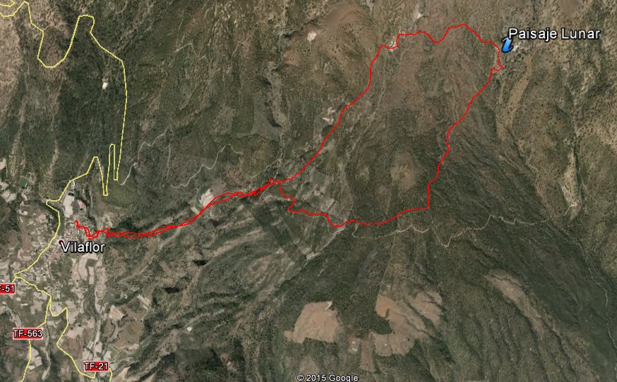
 Aproximate time: 5h
Maximun Height: 1966m (aprox)
Minimun Height: 1382m (aprox)
Distance (Km): 12,4Km (aprox)
Area Information
On that ocassion we are inside the "La Corona Forestal" (Forest Crown) that belongs to the municipality of Vilaflor de Chasna (already in other publications, we have explained the characteristics of that kind of forest). Where the Canary Pine is a great example of vegetation
The lunar landscape (known originally as The Escurriales is the point of interest in the route, though the route is enjoyed by it alone). These peculiar forms, which might be extracted of other planets, are due to the eruptions and the erosive agents as the wind, the rain, etc...
These forms are composed of ashes (a cup of volcanic ash after the eruptions) and pumitas (a kind or rock); being very vulnerable materials to the erosion, that with the years and the erosive agents have gone away eroded. For this motive the landscape is contemplated from a certain distance, due to the fragility of the same ones. And it is a duty and the rights of all of us are enjoying it and to preserve it for the enjoyment of all the generations.
 |
| The Lunar Landscape |
Description of the path
 |
| The drop of the path |
We move up to Vilaflor's municipality, exactly we start the route from San's Pedro Church and Sanctuary of the Brother Pedro, the zone in which we find some Canary houses as paved street. Since to all the places, we can choose for the option to leave the car in the village, it has zone of parking or in the streets or to go on public transport, line 482 (from Arona to Vilaflor) and the line 34 (the Christians to the gap) TITSA.
We initiate the path from the back street to the Sanctuary (a building stone) and between a street where we find the shops (everything is opposite to the church). We take this street until the end and turn to the right, towards a reservoir (this part is lowered) and left hand we find the sign of path Vilaflor-Guajara. (That passes for Chasna's former way, the former route of communication between the north and the south of the island).
 |
| Sancturay of Brother Pedro |
It is a path that is put up signs at all time, for what it has not possible of being lost in the zone (we are inside a path that is equivalent to a Small Tour and to a Great Tour). The first part of the same one, since we leave the village, is in ascent and this one well delimited the way since we pass for different gardens or bench-covers that they find with walls. We do this first ascension from the village up to the forest track. This part is the only path, that is to say that does not have any bifurcation and to return to the village we descend to the same place.
In the forest track, we find the sign that continues indicating the path, we have to cross the track and come up to the following signs and raise some stairs. This part is to circulate, being able to choose the path that we begin and for which we end; since taking an option or another one we come to the same point ( These signs that we find at the end of a few steps justly on the forest track). In this case we took to right hand (and it was a success, since the slope is not so accused as the other option to be rising).

 |
| The first part of the path |
The first part is a bit flat ( we will have to take some slope, but without too many inclination) in almost the whole tour we see the forest track and in some occasion we have to take it to continue to take it in the path. The last part of this section in which we come to the viewing-point of the Lunar Landscape has a bit of inclination, but without a major effort.
At the viewing-point of the Lunar Landscape, viewing-point of The Escurriales, we see an informative cartel, and the Lunar Landscape is to the other side of the ravine (before there was a path that was going to give the lower part of the landscape, but due to the explained in " Information on the zone ", already it is not possible). From the viewing-point we see two zones of concentration of these forms.

 |
| From the viewing-point |
We continue the march of ascendant form during a few meters, up to coming to the maximum point of the slope in which we find again sign that indicates us Vilaflor, or if we continue rising we would come to Guajara (of here the explanation of that in the path we find sings that they indicate Small Tour and Great Tour to us, referring to the path that comes to "Las Cañadas", in this case up to Guajara).
From this point of signs we are descending, with some flat zone. Though to one of these points we go on in front of other peculiar formations very similar to those of the Landscape, where if we do not walk with precaution we can slip ourselves easily. After this point, we pass for an old house that this well to do a stop and to rest.

 |
| 1. Forms similar to Lunar Landscape 2. The signs. |
After a few meters getting down and leaving behind the house, we come to the point of signs, a few meters before the forest track . From this point, we cross again the forest track and get down to the same path that we come from the village.
 |
| The top of this path |
The path in hot days becomes very hard, since the vegetation is not so dense and there is no many shades, and also to add that we are in the south zone of the island where the temperatures are high, especially in summer.
 |
| Forest track |