
History
Before the conquest of Tenerife, this Menceyato was the most important of the south of the island.
It is unknow very well what the limits of it were, but it is believed that the east was the ravine of Santos; the west was the one of Herques; the north extended to 1540 meters high and the south was the sea. While another authors extend it until the beginning of Abona. What is clear is that the land rich of pastures is outside the limit of the valley, beyond Las Cuestas de Tablas, while advancing to the south the impoverishment was remarkable, so the transhumance was forced. In winter they moved to the coast, settling in the vicinity of wells and fountains.
Numbers of archaeological finds in the area, ranging from cave-room in shelters, shells, sailors, caves and necropolis. There are references of looting since the 17th century, being the mummies the most striking elements,. It is thought, that in Barranco de Herques were found at least 1000 mummies (towards 1762-63).
Among the areas of archaeology, other of the places were Chinguaro (in the native language is a low slope canyon), in the head of the Menceyato 3km from Güimar. It was a housing complex formed by natural caves and artificial vacancies. When the virgin of Candelaria appeared, it is in this area where they take her, giving her worship according to their rites.
It is on the beach of Chimisay (sandstone or white stone) where the Virgin appeared, being found by shepherds. It is thought that she was introduced by Franciscan Andalusian missionaries of the convent of Betancuria. These shepherds warn Acaymo, he decided to take it for himself, but being too heavy to take it to Chinguaro, he asked Socorro (Help), which was the origin in this place of hermitage and its pilgrimage.
To remember this appearance, Alonso Fernando de Lugo built a hermitage, and it is in 1550 when there is news of his cult. At the end of that century it was demolished and built again, and in 1643 it was constituted La Cofradía de Nuestra Señora del Socorro. At the place of the apparition, a cross was put on it and pools attached to the wall were added, being like this today.
The pilgrimage and festivities of El Socorro were celebrated in its origins on December 18 and 26, passing in 1837 to the current September 7.
The aborigines of Güimar joined the side of peace (the one of war were those of the north, side that did not want to fall under the clutches of the Castilians) of the conquest, and they played a very important role in some phases of the conquest, especially after the defeat at La Matanza. His Mencey was taken to Soria and baptized, with exile and slavery being his destiny after victory. With the support of Bishop Muros, most of the Guanches were freed (400-500).
After the conquest, in the area remained some aborigines, settled in Guaza, who formed the municipality next to Grancanarios, Andalusian Castilians, Extremeños and Portuguese.
A large part of the valley was destined for sugar, seeing its maximum export in the first half of the sixteenth century. Not being able to compete with Brazil, it is replaced by the vine.
Many of the lands that were divided in this place changed hands on more than one occasion, different heirs, marriage bonds that extended the patrimony, etc
The first nucleus of Güimar is San Juan or Güímar de Arriba, which in 1534 was built the hermitage to San Juan Bautista, next to the house of the Paseo. This in the vicinity of the water springs of the "El Río" and Barranco de Badajoz.
However, at the beginning of the seventeenth century the population moved to the Güímar de Abajo, around an old water tank and where the primitive temple of San Pedro was built in 1602-1608. San Juan would be called Güímar de Arriba.


However, at the beginning of the seventeenth century the population moved to the Güímar de Abajo, around an old water tank and where the primitive temple of San Pedro was built in 1602-1608. San Juan would be called Güímar de Arriba.
Migration is exacerbated by the failure of the vidueño (type of wine) to be sold, but the demographic growth is favorable. The main obstacle for the population is the concentration of land by inheritance, which gave rise to many conflicts for several decades, especially after the Malvasia crisis, and a relaunch of the consumption sector (potatoes, millet and wheat). It was in 1826 that an agreement was reached and centuries of confrontation ended. The neighbours and municipality reserve the 2/3 of the waters and the owners of inheritance the remaining third, triggering in a growth being reflected in Güimar of Abajo (the San Pedro parish and the Dominican Convent are built).
Like all municipalities on the island, the place was not spared the migration of its people, many of them returned, so with these socioeconomic changes affect its urban structure.
The coast was the last area to be urbanized, mainly for the tourist purpose.
Places to visit
Camino del Socorro: BIC 2009. The Camino del Socorro runs east-west. It starts at the confluence of Calle Calvario with Calle Tonazo and Calle Lomo del Molino, until reaching the village of El Socorro.
The first section has a marked urban character, as it passes through the nucleus of the San Pedro de Abajo, although the road is framed by numerous houses with beautiful facades and houses linked to the most wealthy families güimareras.
In the area of the district of Los majuelos and El Calvario the constructions have a more popular and recent character, emphasizing the chapel of Santa Cruz, covered by a vault of half canyon and finished by classic fountain.
From La asomada, the Camino goes into an agrarian landscape.
Reached the Highway TF-1, sorted by a bridge of recent construction, the path adopts a different configuration by having a ground, ground whose layout borders the base of the volcanic cone of Montaña Grande.

(photo: http://www.gobiernodecanarias.org/cultura/patrimoniocultural/bics/index.html?bic=true&cod=235)
Capilla de San Pedro de Abajo y bienes muebles vinculados: BIC 2006. The chapel is a simple construction, with masonry walls and concrete blocks, with cover to four waters of Arab tile.
The most representative element is the great cover of half point in stone. Inside, the frescoes depict medallions with vases on the side walls

Capilla de San Pedro de Arriba y bienes muebles vinculados: BIC 2006. The chapel is a simple construction of a square design, with masonry walls and covered with four waters of Arab tiles.
The most representative element is the great cover of half point in stone. As an extension of the façade appears a wooden Alpende supported by fine pillars of identical material and covered with corrugated sheet metal. Inside, the mural paintings represent the theological virtues, the symbols of the Passion and the weapons of the chapel holder.

Casa del Paseo y Capilla de San Juan y bienes muebles vinculados: BIC 2008. The buildings of the Casa del Paseo and Chapel of San Juan constitute the founding nucleus of the city of Güímar, going back its origins to 1500, when the Adelantado assigns a date to Blasino Plombino or of Inglesco and his brother Juan Felipe, Roman merchants.
They will install a sugar mill, taking advantage of the waters of the River Güímar, setting up a small nucleus between the ravines of El Agua and Badajoz, integrated by workers of the mill and fields of cane and articulated around the main house, possible germ of Casa del Paseo.
The temple was ruined in the seventeenth century, being rebuilt in the eighteenth century and radically modified in its facade during the twentieth. La Casa del Paseo also underwent successive transformations.

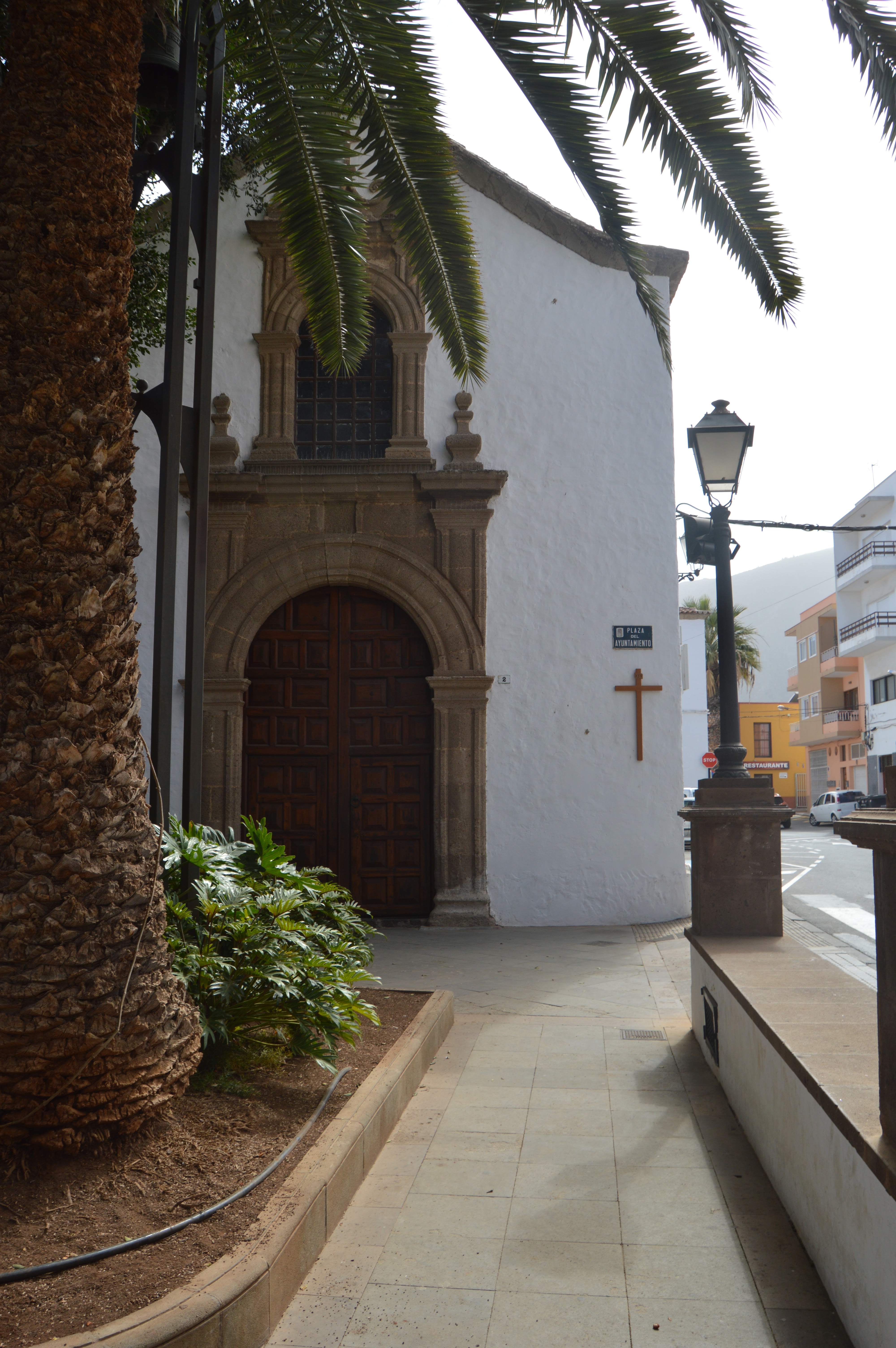
Casco histórico: BIC 2001. The historical centre of Güímar comprises three significant buildings: the Church of San Pedro, the Town Hall -former Dominican convent- and the Church of Santo Domingo, as well as the Chapel of San Pedro de Abajo.
The domestic architecture exists diverse typologies that are worthy of consideration, from those of agrarian origin - older ones - to those of eclectic style, with its detachment from the vernacular tradition.
The dominant model is that of the house with two floors and flat roof (roof), with three or four openings per floor. There are two glazed windows with internal opening shutters. Wooden balconies are infrequent - not so the small balconies, sometimes mere looms, in the windows-


Complejo de Chinguaro: BIC 1999. Little slope Barranquillo. This place is located three kilometers from Güimar and is formed by a set of natural and artificial caves.

Precisely, the image of the Virgin of Candelaria remained in this place around thirty or forty years. It was here that for the first time Aboriginal people worshipped the image. Later, without knowing with certainty the reasons, the image would be transferred to Candelaria. Therefore, until the end of the eighteenth century, this place was only worshiped to Santa Cruz.
It was at that time that it was decided to build a chapel of La Candelaria very close to the cave. Unfortunately it was demolished in the 20th century, although there are remains of the hermitage of the Cruces, built later on the vault of that one.

(photo: http://www.gobiernodecanarias.org/cultura/patrimoniocultural/bics/index.html?bic=true&cod=234)
Ermita del Socorro: BIC 1990. According to legend, back in 1932 (1430-50 according to modern studies), the shepherds found themselves on the beach of Chimisay. This event marked the origin of that place, its hermitage and its pilgrimage.
It was in the first third of the sixteenth century, when the Adelantado, Alonso Fernández de Lugo, decided to build a hermitage as a reminder of his appearance. This hermitage was rebuilt and the Brotherhood of Nuestra Señora del Socorro was built on it. It underwent several reforms and its final works, which extended it to a temple of two naves, were completed in 1894.
Inside it stands out a statue of the Virgin, of the 17th century, made of wood, with fabrics glued and dressed with red tunic.

Iglesia de San Pedro Apóstol y bienes muebles vinculados: BIC 2007. The parish church consists of three naves of equal height. The imafronte facing to the south, finishes in a cornisamiento undulado that betrays the altitude couple of their ship.
The tower, of neoclassical style, is located to the west and does not protrude too much from the ship of the temple.

Iglesia del Convento de Santo Domingo y bienes muebles vinculados: BIC 2008. The temple has a Latin cross plan and a single nave attached to the north side of the convent cloister. The vertical door door with a stone band comprising two overlapping halves: the door and an upper skylight.
La Hidro: BIC 2007. The Historical Site of La Hydro is located in the interfluvian that separates the ravines of Badajoz and the Water, in a sector of the high medians of the Valley of Güímar.
The Central building has two attached orthogonal bodies. The first consists of two floors and roof, existing several openings that are opened in three of its facades. The second body, from a single plant and covered to two waters of uralite, has two windows that open on the south facade. In the interior the machinery - diesel group, alternator, etc.- that in the last years of operation generated the electric energy is conserved.

(photo:http://www.gobiernodecanarias.org/cultura/patrimoniocultural/bics/index.html?bic=true&cod=935)
Llano de la Virgen: BIC 2009. It is an esplanade located in the immediate to the beach of Chimisay.
Located in El Socorro, on the northern margin of the Malpais of Güímar and on a low coastal stretch, known as Beaches of Chimisay (whose morphology has suffered some variations on its original appearance), the Llano de la Virgen represents an enclave of great cultural, symbolic and religious significance, related to the miraculous appearance of the image of the Virgin of Candelaria and the traditional pilgrimage of El Socorro.
Located in El Socorro, on the northern margin of the Malpais of Güímar and on a low coastal stretch, known as Beaches of Chimisay (whose morphology has suffered some variations on its original appearance), the Llano de la Virgen represents an enclave of great cultural, symbolic and religious significance, related to the miraculous appearance of the image of the Virgin of Candelaria and the traditional pilgrimage of El Socorro.
Within this enclosure there is a place called "Field of Ceremony". In it rise some milestones linked to the apparition of the Virgin to the Ganges. The first of these milestones is the tea cross which, according to tradition, points to the place where the Guanches found the image. The second is located in its vicinity, corresponding to the brocal of a brackish water well, used, according to tradition, by the Ganges pastors who were surprised by the Marian appearance. The current aspect of the well, a product of numerous reforms, is that of an elliptical pit 3 m deep. It has a staircase made with songs about the beach, in the same way as the walls of the moat. All this is crowned by a bronchial of whitewashed ashlars.
A few meters from the Field of Ceremony there are still interesting examples of the first habitat of the area. It is a set of caves dug into the turf, which served as a stay for pilgrims on holidays and whose antiquity is difficult to determine whether the tradition of using artificial caves as a habitat among the aborigines of the Güímar valley is valued.

Molino de La Menora: BIC 2007. The Ethnological Site is located in the neighborhood of La Hoya, also known as La Raya.
It only preserves the "bucket" (the annexed rooms have disappeared), through which the water that moved the grinding machinery was lowered. Built in masonry and plastered on its interior and exterior walls, its cylindrical morphology contrasts with the "cubes" of the nearby mills of Chacaica, consisting of superimposed cylinders.
Finally, there is a modest rectangular building, with dry stone walls and covered with four waters built by a cake of mortar, lime and sand without tiles, which responds to a popular housing model quite common in the Güímar Valley.
At the base of the right side of the Barranco del Luchón some caves appear, whose vaults have suffered important collapses, transforming their original morphology. Would constitute possible caves of habitation during the prehispanic period, reused in dates after the conquest. However, the accumulation of drab in their mouths makes it difficult to determine the existence of surface archaeological material or sediment filling.

(photo: http://www.gobiernodecanarias.org/cultura/patrimoniocultural/bics/index.html?bic=true&cod=942)


