lunes, 2 de diciembre de 2019

Cerrillar- La Carnicería

Municiality: La Orotava
Aproximate duration: 1:40(go and return)
Maximun height: 2277m
Minimun height: 2212m
Distance: 2,3km (one way)


Area Information

The name of this path is due to 2 mountains: El Cerrillar y la Carniceria one. 

Among the vegetation of the area we find the brooms, elbow (Adenocarpusviscosus), Hierba Pajonera (Pterocephaluslasiospermum), etc.


Path

Description of the path


The drop of the path


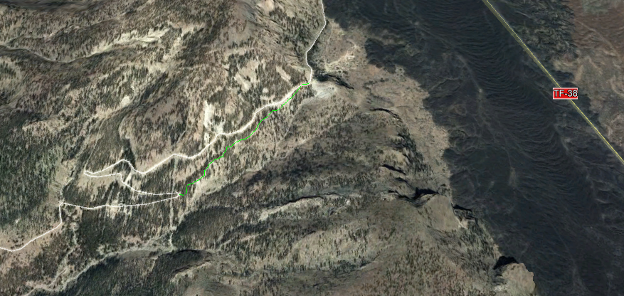
We started this trail on TF-24 La Esperanza. On the right hand  (if we go towards the Observatory) or on the left one (if we go to El Portillo) we see a fence between some stone walls and some gap to leave the car.


Just to the left of the fence, we see the path on foot. After about 5-7 minutes walking along the track, we find the signs that tell us if we take for Arenas Negras (side, we are going to) or for the Guajara slit, trails towards the one we are going.


The path, which is linear, is formed on the ground and each certain point we see the sign that we are on track 37. There are areas that can lead to confusion, but we see how it has been made a way between the brooms (unfortunately, many of them dry).
Views
The path has a low level of intensity, and almost all the way is in plain, only the last part before the connection with Arenas Negras, has a small ascent, but nothing complicated.

We finish the path when we come to connect with the one of Arenas Negras. One option is to make the circle of Arenas Negras and go back to the one of Cerrillar, or as it is this case, we went back to the car by the same path.

Path
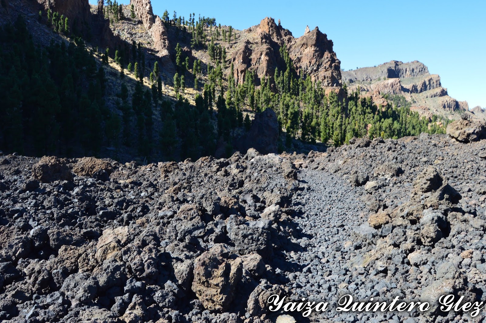
At all times, except for the last stretch, we see the Teide and of the observatory; and sometimes we can see La Palma above La Fortaleza.

Walking here , it is possible to go from Portillo to Izaña without having to take the road.

Views

We’re on the high mountain and the shadow is scarce. On an ideal trail to perform between the months of May-June with the flowering of the broom, but watch out for the bees.


Path and views


viernes, 1 de noviembre de 2019

El Cerrillar-La Carnicería

Municipio: La Orotava
Duración aproximada camino:  1:40(ida y vuelta)
Desnivel máximo: 2277m 
Desnivel mínimo: 2212m 
Distancia [Km]: 2,3Km (ida)


Información sobre la zona


Este sendero debe su nombre a las montañas del Cerrillar y la Carnicería. 


Sendero
Entre la vegetación de la zona encontramos las retamas, codeso (Adenocarpusviscosus), hierba conejera (Pterocephaluslasiospermum), etc

Entre la fauna, cabe destacar que en todo el camino encontramos los escarabajos y lagartos, también conejos, que no los vemos pero si las cagaditas a lo largo de todo el sendero.

Sendero

Descripción de sendero


Recorrido y Mapa de Elevación
Iniciamos este sendero en la carretera TF-24 por La Esperanza. A mano derecha de la misma (si vamos sentido al Observatorio) o a mano izquierda (si vamos al portillo) vemos una valla entre unas paredes de piedra y algún hueco para dejar el coche.

Justo a la izquierda de la valla, vemos el sendero a pie. Después de unos 5-7 minutos caminando por la pista, encontramos las señales que nos indican si cogemos para Arenas Negras (lado para el que vamos) o  para la degollada de Guajara, senderos hacía el que nos dirigimos.


Inicio sendero
El sendero, que es lineal, se encuentra formado en el suelo y cada ciertos puntos vemos la señal que indican que nos encontramos en el sendero 37. Hay zona que puede llegar a confusión, pero vemos como se ha hecho camino entre las retamas (muchas de ellas secas lamentablemente).

El sendero tiene un nivel de intensidad bajo, y casi todo el camino es en llano, sólo la última parte antes de llegar a conectar con el de arenas negras, tiene un pequeño ascenso, pero nada complicado.


Sendero
Finalizamos el sendero al llegar a conectar con el de Arenas Negras. Una opción es realizar el circular de arenas negras y volver de nuevo al de Cerrillar, o bien como es este caso, volvimos de nuevo hacia el coche por el mismo sendero.

En todo momento, excepto en el último tramo, vemos el Teide, tenemos vistas al observatorio, y si el día está claro y no hay calima, podemos ver La Palma asomando por encima de la fortaleza.


Vistas
Lo que permite este sendero es poder llegar desde el Portillo hasta Izaña sin necesidad de coger la carretera.

Estamos en alta montaña y la sombra escasea. En un sendero idóneo para realizar entre los meses de mayo-junio con la floración de la retama, pero cuidado con las abejas. 

Sendero corto ideal para irse iniciando en la alta montaña. 


Sendero


martes, 1 de octubre de 2019

Boca de Chavao

Municiality: Vilaflor
Aproximate duration: 0.20 min (go) 0.30 min (return)
Maximun height: 2078m
Minimun height: 1973m
Distance: 713 m


Area Information

This was the main access road to Las Cañadas of the inhabitants of the region of Isora, having several ramales (ways) coming from the different locations. 

We are walking at all times between pines, as we are in La Corona Forestal of the south of the island.

Path

Description of the path


The drop of the path

We are on track number 35 of the National Park of the Teide. To reach this path we must first walk along the path number 18 Chavao, either from Las narices del Teide viewpoint (just below the road) or from the Juan Évora Ethnographic Museum. In this case it was departing from the museum to reach this path.

We are on the road Tf-21 of Vilaflor. The area has parking, but which has a schedule to keep in mind.

Path

To reach the area, we can take different means of transports like Guagua (Bus), which from Puerto de la Cruz is line 348. From Costa Adeje, line 342. We take the road TF-21 (for La Orotava or for Vilaflor); TF-24 (for La Laguna); and TF-38 (Boca Tauce-Chío).

The path is signposted, but there is a different time of going and returning for the same one, due to the inclination..There are about 100 meters of unevenness, so to ascent always is more difficult.

Views
The path is signposted on the ground (it is well defined the path). On one side is the ravine (it is  not difficult to fall), and the other side is the wall of El Cedro. 


This path continues to Tagara, but if you only want to walk this one that in short time, the end is when we find the trail sign.


 Views
Path
Path


domingo, 1 de septiembre de 2019

Boca de Chavao

Municipio: Vilaflor
Duración aproximada del trayecto: 0:20 min (ida) 0:30 (vuelta)
Desnivel máximo: 2078m
Desnivel mínimo: 1973m
Distancia [Km]: 713m


Este mes toca hablar del sendero Boca de Chavao, ya que para acceder al mismo, hay que ir primero por el de Chavao, que fue la anterior publicación. 

Información sobre la zona


Esta era la principal vía de acceso a la cumbre, de los habitantes de la Comarca de Isora, teniendo varios ramales procedentes de los diferentes caseríos.

Vamos en todo momento entre pinos, ya que estamos en la Corona Forestal del sur de la isla.


Señal y sendero

Descripción del sendero


Recorrido y mapa de elevación

Nos encontramos en el sendero número 35 del Parque nacional del Teide. Para llegar a este sendero primero debemos de caminar por el sendero número 18 Chavao, bien desde el mirador de narices del Teide (da justo por debajo de la carretera) o bien desde el museo Etnográfico Juan Évora. En este caso se partió desde el museo para llegar a este sendero.

Estamos en la carretera Tf-21 de Vilaflor. La zona dispone aparcamiento, pero el cuál tiene un horario que hay que tener en cuenta.

Sendero
Para llegar a la zona podemos tomar diferentes medios como la Guagua, que desde el Puerto de la Cruz es la línea 348. Desde Costa Adeje, línea 342. Tomamos  la carretera TF-21 (por La Orotava o por Vilaflor); TF-24  (por La Laguna); y  TF-38 ( Boca Tauce-Chío).

El sendero esta señalizado, pero hay diferente hora de ida y vuelta por el mismo, debido a la inclinación, son unos 100 metros de desnivel, por lo que la subida siempre cuesta más.

Vistas
El sendero esta señalizado en el propio suelo, ya que esta marcado el camino, de todas formas por el lado del barranco es difícil que nos salgamos del mismo ya que caeríamos, y el otro lado es la pared del Cedro.

Este sendero continua hacía Tágara, pero si solo se desea recorrer este que en tiempo es corto, vemos el final cuando encontramos el cartel de sendero.


Sendero y Pico Viejo y Teide

jueves, 1 de agosto de 2019

Chavao

Municiality: La Orotava
Aproximate duration: 1:40
Maximun height: 2077m
Minimun height: 2040m
Distance: 2,10Km

Area information

During the walk, in addition to appreciating the typical flora of Las Cañadas (broom, walnut, elbow, broom, etc.), curious geological shapes like the lava beds (lavas almohadillas) and small fields of chordate lava (lavas cordadas) can be seen.

Landscape

Description of the path


The drop of the path


We are on track number 18 of the National Park of the Teide. This path is not circular, so we return to the same starting point along the same path. The good thing about this is that things that were left behing, can be appreciated.  

We started walking at the Juan Évora Ethnographic Museum, the last goat to live in the Teide. In this area there is parking, but it has an hour of closure, so if we do this  trail or Boca de Chavao (35); or we leave from here to Tagara (go and back), take into account this time.

Path
This place is on the TF-21 road that goes to the municipality of Vilaflor.

To reach to here, we can take different means of transports like Guagua, which from Puerto de la Cruz is line 348. From Costa Adeje, line 342. We can also go by car, having a parking area.

We take the road TF-21 (for La Orotava or for Vilaflor); TF-24 (for La Laguna); and TF-38 (Boca Tauce-Chío)

Path

It is a path that does not have much inclination, and it runs both between pine forest and between flows. Take into acount that it is easyto  have a silly fall.

On the right we have Pico Viejo, El Teide; and on the left hand side the walls and the area of the forest crown from the south of the island. From the viewpoint we head towards the Roque del Cedro leaving to the left La Cañada del Cedro.

Landscape
It is relatively flat, without great inclinations and is signposted at all times.

Pine
Landscape