Aproximate duration: 08.00 Hours
Maximun height: 3718m
Minimun height:2135m
Distance: 15Km
Area Information
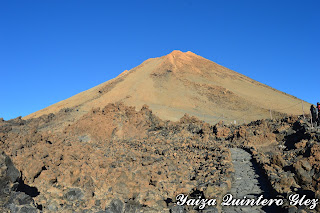
This path that we are realizing is getting down El Teide, walking through PicoViejo. El Teide was declared as Natural Heritage of the Humanity in 2007.
Pico Viejo is a crater of approximately 800 meters of diameter and it is in approximately 3.100 meters of altitude. (To remember that it is prohibited to get inside the Crater). Pico Viejo shares the same volcanic building that El Teide.
The vegetation that we find is the characteristic of the area, as Brooms (Spartocytisus supranubius), Hierba Pajorera (Descurainia bourgaeana) and Rosalillos de Cumbre (Pterocephalus lasiospermus).
 |
| Pico Teide and landscape |
Description of the path
 |
| The drop of the path |
We are going to realize more than one path in Las Cañadas del Teide, extactly 2.
To come to the National Park, we can take the public transport: taxi or Bus (lines 348 and 342) and the car (parking in the qualified parkings).
We start by rising in the Teleférico del Teide (cable car). Once we come up, take the path to access to the peak (to remember that to rise it is necessary to have a permit, the rise during the day is restricted and the continuance of visitors in the area is 2 hours).
 |
| Path |
On having come above, one enjoys of impressive views of Tenerife (north, south, eats and west) and of other islands. It is possible to see Gran Canria, La Gomera and La Palma. It is more difficult to see the other ones, El Hierro, Lanzarote and Fuerteventura.
We begin to go down, and on having come to the shed of the teleférico, take to the right side (the left side, we go to the viewing-point of La Fortaleza, number 11). We take the number 12 Viewing-point of Pico Viejo.
 |
| Pico Viejo |
After coming to the viewing-point of Pico Viejo, we continue the path number 9 Teide- Pico Viejo. The path has indications all the time (signs and also we see the path drawn in the own soil). We carry to extremes the precautions since a fall in the zone is the easiest thing.
We are walking for zones of washes, treading on volcanic bombs and also zones where the soil is more unstable, there being many gravel. On having come already to the crater of Pico Viejo, we will have walked for 1 hour and 30 minutes (this duration is relative according to the people, in our case we were slow, observed the landscape, making photos and making stopping)
 |
| Path |
We come to Pico Viejo, and at the bifurcation with the path 23 Regatones Negros. After seeing the crater, we return again to walk to the bifurcation, and take the path number 23. This path has a duration going down for 3 hours, whereas rising it is 4 hours.
 |
| Landscape |
When we start to descend, to our back is Pico Viejo, and there are some places from where it is imposible to see El Teide. Always having in front of us, Las Cañadas with the highest point Guajara.
 |
| Landscape |
We cross zones of washes, and the last point coming to Los Roques de García, we tread on the lava called Pahoe hoe.
We come to the crossing with Los Roques, and continue the path towards the parking, directly to El dedo de Dios (image of the bill of 1000ptas). We go for the pokings, up to Las Cañadas, and here to the right hand, we find the path 19 of Majúa. At the end of this last one, we find the car. To know more on the path Majúa, read:
http://andandoportenerife.blogspot.com.es/search/label/Patrimonio%20Natural
http://andandoportenerife.blogspot.com.es/search/label/Patrimonio%20Natural
This path was realized as a circulate one, returning to the starting point. Other option, is to leave one car in the parking of Los Roques ( we left it close to El Teleferico).
This path was realized in October, there is neither shade nor covered zone, from what many protections is advised and liquidate in case of realizing it in Summer.
 |
| Landscape |
To reserve cable car:
https://www.volcanoteide.com/en/teide_cable_car
To access to Pico Teide:
https://www.reservasparquesnacionales.es/real/parquesnac/usu/html/detalle-actividad-oapn.aspx?ii=6ENG&cen=2&act=1


