lunes, 20 de marzo de 2017

La Matanza de Acentejo

Municipality: La Matanza de Acentejo


History


Before the Castilian epoch, the municipality was integrated  under the Menceyato de Taoro and in the Menceyato de Tacoronte (depending wherefrom it is reading, we can find it inside one or another one, or of both Menceyatos).

Always it  has been characterized for being a municipality of the slopes and of irregular volcanic washes. The limit is divided between  the Ravine of La Cabrera with El Sauzal, and the San Antonio one with La Victoria.

View from La Matanza
In this municipality Los Guanches obtained the victory on the conquerors (if there there comes the name of the municipality, taken on the battle that the Original inhabitants of the Canary Isles gained on the Castilians), event that it  forced Fernandez of Lugo to retire from the island and to look for reinforcements. It was in Acentejo's ravine (though it is doubted on the exact place) where the battle takes place, taking advantage Los Guanches of the local orography for the ambush.

Since it finishes the conquest, in the territory cereals and grapevine are cultivated. In the XVIIth and XVIIIth century the development of the vineyard (especially the white one, the red wine interferes at the end of the XVIIIth) in this zone, raises it to the regional hegemony, close to La Victoria. There exists a small elite of local owners (though most they were laborers and lessees), enriched with the benefits of the wine and the agriculture for the subsistence. But the majority of the fertile lands concerned  to oligarchies laguneras (people from La Laguna) and orotavenses (people from La Orotava). In the high and medium zones they predominate over the cereals, wheat, and then it appears eats it and the mill.

Some houses
This municipality does not remain exempt from the wine crises that were lived, by what they are summarized in migrations. It is the wheat the production that manages to survive. With the migrations of the males to obtain send, in the field relevancy charges more the women and children. During the whole history, the municipality being seen the inhabitants declining and to get bigger, according to the crises or the economic recoveries that are happening.

In this municipality a deposit existed towards the ends of the XVIth. The crafts had representation very small. The Slaughter was a place of step obliged to all those persons who were going to the valley and northwest, for what it possessed from the ends of the XVIth a put and inn. In the population, they were not possessing doctors, but quacks.

Some houses

The population was centered in  the center of the town, and then some dispersed houses for the rest of the municipality. They were possessing several fountains, but they were not in use for the irrigation for not having the funds to be able to finance the work.

The restaurants constitute the major source of employment in this locality. In the soil an essential culture of grapevine continues to exist..

Some houses

Representative Buildings 


It is possible to say the municipality possesses the best city center preserved of the region, with casonas (big houses) of agrarian bourgeoises. The principal temple survived a fire in 1936, for what in the current temple some images remain.

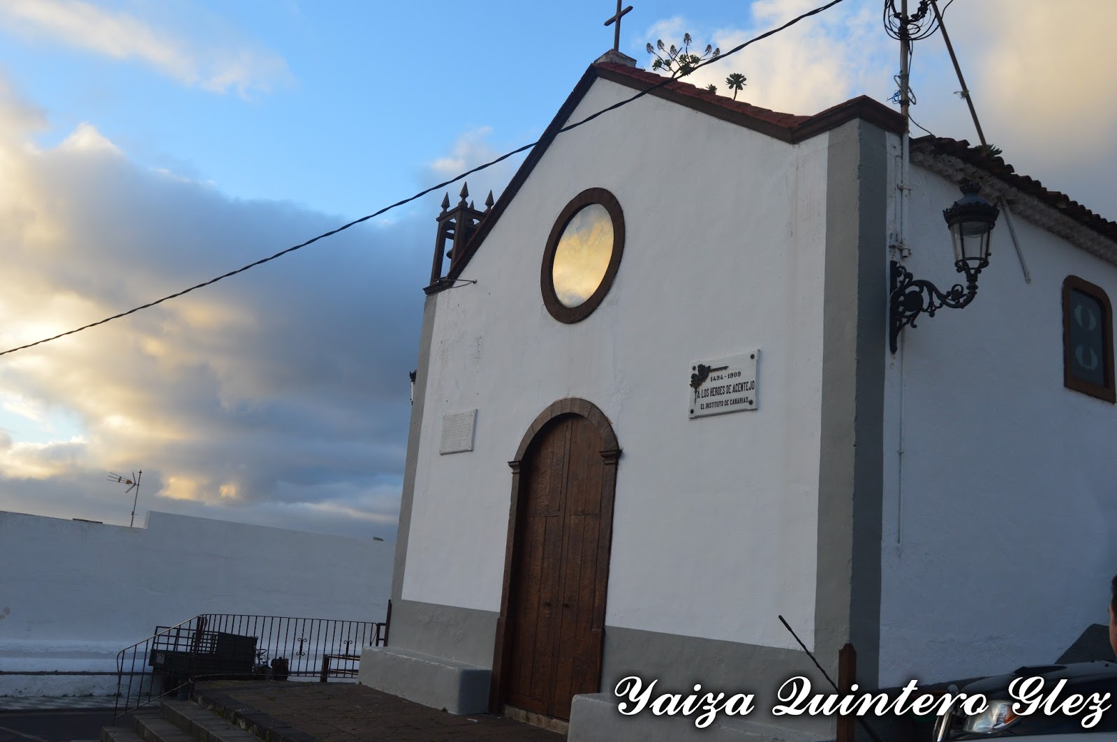
San Diego Hermitage: it was in an estate. It was modified and the current temple is about 1947.

San Diego hermitage

Nuestra Señora de Guía Hermitage: in 1679, close of an estate with balconada (a big balcony)

Nuestra señora de Guía Hermitage
San Antonio Hermitage: raised by one of the protagonists of the battle, who promised to construct it in the same place if his  boss was saving it from this ambush. From these dates there was built by a worn image of the peninsula, that all the tradition that was the first image brought to the island. The holiday of San Antonio is and continues being very popular, where they were peregrinating with the cattle, of which he is the protector saint.

San Antonio hermitage

Acentejo's ravine: declared BIC. It is also known as the Ravine of San Antonio, that it constitutes the principal channel of drainage of the region. It  is born in the north slope of the Dorsal Mountain chain on the island, finishing in the Top of the Sabina (in the coast), after more than 6 linear km from the tour.

It presents a great number of caves and natural hollows that line up along the front of both slopes, many of which would have known a use habitacional, cattle or funeral during the pre-Hispanic stage.

The majority of the caves placed over the Highway of the North have been re-used by cattle purposes or as rooms of equipment, and most of the archaeological landfill has got lost. Nevertheless, they constitute a paradigmatic model of the prehistoric habitat of the north of Tenerife.

Ravine between La Matanza and La Victoria
La Matanza painting

Other places to visit in the main street:

Lagar of the real Street N º 198: El Lagar ( it is used to crush wine)  is inside a rectangular construction, of approximately 50 m2 of surface, which walls are made of basaltic blocks of hewn stone. In the angles of the construction stones have been in use in the corner of basaltic nature. Only the south wall shows a different, more modern structure, since it is raised by prefabricated blocks.


El Hospicio: placed at the edge of the real way, which the people were crossing. In 1732 it was constructed a Franciscan hospice  to receive in the same one the Franciscans and religious that were travelling between La Laguna and La  Orotava. Nowadays the houses of high place remain and low with the gallery, the garden and the hermitage.

In Calle Real

Calle Real

Others of the real estate to visiting are Fuente del Pino, Casona Doña Sixta, Salvador Hermitage, La Casa del Barco etc, across the nucleuses Acentejo, El Caletón, Guía, La Matanza, Las Breñas, San Antonio y San Cristobal. 


Casa del Barco
El Salvador Hermitage
Doña Sixta House

martes, 28 de febrero de 2017

La Matanza de Acentejo

Municipio: La Matanza de Acentejo 

Historia


Antes de la época castellana, el municipio estaba integrado bajo el Menceyato de Taoro y en el Menceyato de Tacoronte (dependiendo de donde se lea, podemos encontrarlo dentro de uno u otro, o de ambos Menceyatos). Siempre se ha caracterizado por ser un municipio de pendientes y de irregulares coladas volcánicas. Su limite se divide entre el Barranco la Cabrera con el El Sauzal y el barrando de San Antonio con la Victoria.

En este municipio sucede la trama bélica, lugar donde Los Guanches obtienen la victoria sobre los conquistadores (de ahí viene el nombre del municipio, tomado de la batalla que ganaron los Guanches sobre los castellanos), suceso que obligó a Fernandez de Lugo a retirarse de la isla y buscar refuerzos. Es en el barranco de Acentejo (aunque se duda sobre el lugar exacto) donde tiene lugar la batalla, aprovechando Los Guanches la orografía del lugar para la emboscada.

Casa en La Matanza
Desde que finaliza la conquista, en el territorio se cultivan cereales y vid. En los siglos XVII y XVIII el desarrollo del viñedo (especialmente el blanco, el tinto se introduce a finales del XVIII) en esta zona, lo eleva a la hegemonía comarcal, junto a la Victoria.  Existe una pequeña élite de propietarios locales (aunque la mayor parte eran jornaleros y arrendatarios), enriquecidos por los beneficios del vino y la agricultura para la subsistencia. Pero la mayoría de las tierras fértiles pertenecían a oligarquías laguneras y orotavenses. En las zonas altas y medianas predominan los cereales, trigo, y luego aparece la papa y el millo.

Casa en La Matanza

Este municipio no queda exento de las crisis vinícolas que se vivieron, por lo que se resumen en migraciones. Es el trigo la producción que logra subsistir. Con las migraciones de los varones para obtener remeses, en el campo cobra más relevancia las mujeres y niños. Durante toda la historia cuenta con migración, viéndose el municipio decaer y agrandar sus habitantes según las crisis o las recuperaciones económicas que van sucediendo.

Vistas en La Matanza
En este municipio existió un pósito hacia finales del XVI. La artesanía tenía muy poca representación. La Matanza era un lugar de paso obligado a todas aquellas personas que se dirigían al valle y noroeste, por lo que contó desde finales del XVI con una posada y mesón. En la población no contaban con médicos, sino curanderos.

La población se concentraba en el casco, y luego algunas casas dispersas por el resto del municipio. Poseían varias fuentes, pero no se utilizaron para el riego por no tener fondos para poder costear la obra.

Los restaurantes constituyen la mayor fuente de empleo en esta localidad. En su suelo sigue existiendo un esencial cultivo de vid..

San Antonio

Inmuebles a visitar


La Matanza se puede decir que posee el mejor casco conservado de la comarca, con casonas de burgueses agrarios. El templo principal sobrevivió a un incendio en 1936, por lo que en el templo actual se conservan algunas imágenes.


Ermita San Diego: estaba en una hacienda. Fue modificada y el templo actual es de 1947. Destaca un arco monopial, apoyado sobre columnas con basa y plinto. Se accede a través de un arco de medio punto. Adosada se encuentra una torre-campanario.

Ermita de San Diego
Ermita Nuestra Señora de Guía: en 1679, junto a una hacienda con balconada.

Ermita Nuestra Señora de Guía

Ermita de San Antonio: erigida por uno de los protagonistas de la batalla de la Matanza quién prometió construirla en ese mismo lugar si su patrón lo salvaba de esa emboscada. Desde estas fechas se edificó con una imagen traída de la península, que cuanta la tradición que fue la primera imagen traída a la isla. La fiesta de San Antonio es y sigue siendo muy popular, donde peregrinaban con el ganado, del que es el santo protector.

Ermita San Antonio

Barranco de Acentejo: declarado BIC. también conocido como Barranco de San Antonio, que constituye el principal canal de drenaje de la comarca. Nace en la vertiente norte de la Cordillera Dorsal de la isla, desembocando en la Punta de la Sabina, tras más de 6 km lineales de recorrido.

Presenta un gran número de cuevas y oquedades naturales que se alinean a lo largo del frente de ambas vertientes, muchas de las cuales habrían conocido un uso habitacional, ganadero o funerario durante la etapa prehispánica.

 La mayoría de las cuevas situadas por encima de la Autovía del Norte han sido reutilizadas con fines ganaderos o como cuartos de aperos, y la mayor parte de su relleno arqueológico se ha perdido. No obstante, constituyen un modelo paradigmático del hábitat prehistórico del norte de Tenerife.

Baranco entre La Matanza y La Victoria
Barranco que separa La Matanza de Santa Úrsula

Otro inmuebles a visitar en La Calle Real:

Lagar de la Calle real Nº 198: El lagar se encuentra en el interior de una construcción rectangular, de unos 50 m2 de superficie, cuyos muros están fabricados con bloques basálticos de cantería. En los ángulos de la construcción se han utilizado piedras esquineras de naturaleza basáltica. Sólo la pared meridional muestra una estructura diferente, más moderna, ya que está levantada con bloques prefabricados y cemento.


El Hospicio: colocado al borde del camino real, que atravesaba el pueblo. En 1732 se construyo un hospicio franciscano para acoger en el mismo a los franciscanos y religiosos que transitasen entre La Laguna y La Orotava. Hoy en día se conservan las casas de alto y bajo con la galería, la huerta y la ermita.

Calle Real
Calle Real

Otros de los inmuebles a visitar son Fuente del Pino, Casona Doña Sixta, Ermita el Salvador, La Casa del Barco, etc a través de sus núcleos Acentejo, El Caletón, Guía, La Matanza, Las Breñas, San Antonio y San Cristobal. 

Casa del Barco
Ermita El Salvador
Casona Doña Sixta

martes, 24 de enero de 2017

The path from Garachico to San Juan del Reparo

Municipality: Garachico
Aproximate time: 1:30h (go) /1h(return)
Maximun Height: 430 m (aprox)
Minimun Height: 16m (aprox)
Distance: 2,6 km


Area Information


Garachico's historical villa, it was devastated by the volcano Trevejo or Arenas Negras in 1706. Until that moment, here was the most important port of the island.

To know about more eruptions of the island visit:  https://www.facebook.com/Andandoportenerife and on Garachico's municipality: http://andandoportenerife.blogspot.com.es/2013/10/casco-de-garachico.html 


The beginning of the path
The path passes for this hillside, through lavas and  the main part of the same one, we walk along the former camino real (an ancient track that connects two places).

Between the vegetation of the zone, we find Magarzas (Argyranthemum frutescens), Tabaibas (Euphorbia atropurpurea) and Vinagreras (Rumex Lunaria). Little by little we are walking between Heathers (arboreal Heather), some Tuneras (maximum Opuntia), a mixed pine grove, Fern (Pteridium aquilinum), Moss (Bryophyta), etc.

Garachico

Description of the path 


The drop of the path

We begin the tour in Garachico, a  northern municipality, in the northwest of the island of Tenerife.

To come here, we can come in the car and parked it in the parkings of village or in public transport (line 363 and 107, they go by this zone). Though we do not name it very much, a taxi also is an option of transport, and in tours as this one, that they are not linear, that is to say,  not to return to the  beginning point, we can ask to gather us at the far end.

This path is not to circulate, so on, having come to the zone of San Juan del Reparo, we return again for the same route towards Garachico (It is possible to continue with this track to La Montañeta and from there up to El Chinyero. From Garachico to El Chinyero are 12,5Km of distance).

Path
We can find the signs along the circuit  in stones or bollards. But also we have the help that the path is well-defined in the soil (former royal way).

It  is in continuous accenssion, we are rising in the shape on zigzag way, so do not wait  for any flat zone in which to walk. It is necessary to take enough liquid, there are zones of shades, but not many, and to remember that we rise in the hillside. There are zones where the drainpipes are discovered and we can refresh with the water, and especially  not throw  anything, because it is in use for the people and cultures.

Views
We begin in the back of the Town hall, there we find the sign of the path and the map of the path towards El Chinyero. After a few meters in the village, we begin the accession across cement stairs. On having finished this section we come to a shed with seats of wood. We cross the street and in left hand, we see the following sign

This section, wich we raise, have many market-gardens and the stone pavement is scanty. On having finished it, we come to a road where there are some houses and is without an exit. To left hand there is a door for the one that can pass walking and to right hand, we see the continuation of the path and the sign that indicates it.

Atarjea 
From this section, we continue rising in zigzag. There are zones that the stone pavement is well and others totally ruined (to the being the hillside is a zone of enough slides). We find pines that give us shade, as well as totally covered  zones of pinocho (bleed pinar, pinocho o pinocha  depends on the zone of the island, it is said by some means or another).

From that tour, it is possible to see Garachico, the Northwest of the island (Los Silos and Buenavista), as well as the zone of El Guincho with the banana plantation and the north zone (Anaga) if the day is good we can see the end of the island.

One section of the path

We finish the tour on having come to the road that continues up to San Juan del Reparo, finish coming to a house to the end of the path. To come to this point, we returned again towards Garachico, and we see the sign that indicates us that we enter a protected zone (that also it  indicates us that we were going out of the same one on having finished the path).

Remember that it is not advisable to make this tour in rainy areas, because many of the stones on the road are quite smooth and the inclination of some of the exceptional steps.

Garachico from the path

domingo, 1 de enero de 2017

Garachico-San Juan del Reparo


Municipio: Garachico
Duración aproximada camino: 1:30h (ida) 1h (vuelta)
Desnivel máximo: 430 m (aprox)
Desnivel mínimo: 16 m (aprox)
Distancia [Km]: 2,6 km

 Información sobre la zona


La villa histórica de Garachico, fue arrasada en gran parte por el volcán Trevejo o Arenas Negras en 1706. Pueblo que hasta la fecha tenía  el puerto más importante de la isla. 

Para saber más de erupciones de la isla visitar https://www.facebook.com/Andandoportenerife y sobre el municipio de Garachico: http://andandoportenerife.blogspot.com.es/2013/10/casco-de-garachico.html 

El sendero discurre por esta ladera, trayectoria que cogieron las coladas lávicas, y caminamos por gran parte del mismo sobre el antiguo Camino de Herradura (camino que unía el municipio con la zona alta del mismo y el Tanque) .

Garachico
Entre la vegetación de la zona encontramos Magarzas (Argyranthemum frutescens), Tabaibas (Euphorbia atropurpurea) y Vinagreras (Rumex lunaria). Poco a poco vamos caminando entre Brezos (Erica arborea), alguna Tunera (Opuntia maxima), un pinar mixto, Helecho (Pteridium aquilinum), Musgo (Bryophyta), etc.

Puerto de Garachico (nuevo)

Descripción del recorrido


Recorrido y mapa de elevación
Comenzamos el recorrido en el municipio norteño de Garachico, en el noroeste de la isla de Tenerife.

Para llegar aquí podemos llegar en coche y dejarlo aparcado en los aparcamientos del pueblo o bien en transporte público (línea 363 y 107), que pasan por la zona. Aunque no lo nombremos mucho, un taxi también es una opción de transporte, y en recorridos como este que no son lineales, para no volver al mismo por la misma zona, podemos pedir que nos recojan en el otro extremo.

Vistas desde el sendero
Este sendero no es circular, así que al llegar a la zona de San Juan del Reparo, volvemos de nuevo por el mismo recorrido hacia Garachico (el sendero si queremos continua hasta La Montañeta y de ahí hasta el Chinyero. Desde Garachico hasta el Chinyero son 12,5Km de distancia).

El sendero esta en todo momento señalizado, y cada ciertos metros encontramos lo que nos queda hasta llegar a San Juan del Reparo (en km, sobre todo en Garachico, al pasar de esta zona ya no encontramos señales como esta); y la señales que nos indican como continua el sendero (sobre todo en piedras). Pero también tenemos la ayuda que el sendero está bien definido en el suelo (antiguo camino real).

Parte del sendero
Es en continua ascensión, vamos subiendo en forma de zig-zag, así que no esperen en ningún momento alguna zona llana en la que caminar. Es un sendero en el que hay que llevar bastante líquido, hay zonas de sombras pero muchas descubiertas y recordar que subimos por la ladera. Hay zonas en donde las atarjeas están descubiertas y podemos refrescarnos con el agua,  y sobre todo no echarle nada ya que se utiliza para el pueblo y cultivos.

Comenzamos en la trasera del Ayuntamiento, ahí encontramos la señal del sendero y el mapa del sendero hacia el Chinyero. Tras unos metros en el pueblo, comenzamos la ascensión a través de escaleras de cemento, al terminar este tramo llegamos a una caseta con asientos de madera. Cruzamos la calle y a mano izquierda vemos la siguiente señal.

Ladera
Este tramo que subimos se encuentra rodeado de diferentes huertas, y el empedrado es escaso. Al terminarlo llegamos a carretera donde hay algunas casas y es sin salida. A mano izquierda hay una valla por la que se puede pasar caminando y a mano derecha vemos la continuación del sendero y la señal que lo indica.

A partir de este tramo, continuamos subiendo en zig-zag. Hay zonas que el empedrado esta bien y otras totalmente destrozado (al ser una ladera es zona de bastantes deslizamientos). Encontramos pinos que nos dan sombra, así como zonas totalmente cubiertas de pinocho (ó pinocha, depende de la zona se dice de una manera u otra).

Destacar del recorrido, las vistas de Garachico, del Noroeste de la isla (Los Silos y Buenavista), así como la zona del Guincho con su platanera y la zona norte (Anaga, si el día está bueno podemos ver el extremo de la isla).

Sendero
Finalizamos el recorrido al llegar a la carretera que continua hasta San Juan del Reparo,  llegamos a una casa al fin del sendero y una caseta de telecomunicaciones. Llegados a este punto, volvimos de nuevo hacia Garachico, y vemos la señal que nos indica que entramos en una zona protegida (que también nos indica que salíamos de la misma al terminar el sendero).

Recordar que no es muy aconsejable hacer este sendero en épocas de lluvia o chispando, ya que muchas de las piedras en el camino están bastantes lisas y por la inclinación de las pendientes por donde caminamos.

Vistas de Garachico

martes, 22 de noviembre de 2016

La Victoria

Municipality: La Victoria de Acentejo


History

In the pre-Hispanic epoch this place belonged to the Menceyato de Acentejo. It was found some proof of the existence of Los Guanches in the sepulchral cave in El Caletón, with human remains and ceramics.

In this place,  Alonso Fernandez de Lugo won the victory to Los Guanches,being able get this way in Taoro. For that reason this place was called La Victoria (the victory). In 1945 the battle took place near the Ravine of La Matanza, and as a commemoration of the victory a hermitage was built under the name of our Lady of the Victory. After this battle, many aborigines were enslaved.

In La Victoria

When the distribution of lands was given, this zone was considered cerealística (grain culture). From the 16th century the grapevine was begun to be cultivated  (in the third decade), in low zones and mediocrities. This gives a place to the concentration of propertied absentees.

Cereals and wine are the principal productions, of dryness since the irrigation does not exist (that was a reason of some conflicts in the municipality). There was a spring that had an unequal form of distribution of the water. Since 1920 more conflicts took place due to the opening gallery in the zone, whose owners were foreign or not residing in the zone.

Town Hall

As for the handcrafted production, slabs and a blacksmith were producing. In the municipality, it was not possessed a public granary (as in other municipalities); the middle class of the zone was agrarian, and most of the primogenitures belong to foreign owners. 

The population, like it happened in other municipalities, grows and descends according to the economic growth; migratory movements were seen when the principal products stop being exported (in this municipality it is the wine).

To the Church

Though it is not a very trustworthy information, La Victoria accedes to the municipal independence in 1813, and in 1900 it reaches the title of Villa. In the coastal zone the banana plantation is implanted  after the second world war, but it  is not very significant.

The population leaves the primary sector when the tourism activity was appeared. In the zones of mediocrities we see potatoes cultures and vineyards, which have been revealed thanks to the name of origin. 


Representative buildings


We cannot speak about historical city in the strict sense in La Victoria, since only any houses stay about the parish. They also find some rural household  distributed around the municipality (but all this surrounded with more modern constructions).

Nuestra Señora de la Victoria: declared BIC. It is find the pine, close to the paris, of which the bells were hung after the victory (since the first hermitage was a very precarious construction, in dry stone and of an unique ship). In 1537 the hermitage begins to be built. In 1540 one saw favored by the contribution in lands and in taxes that there leaves one of the major owners of the zone, leaving it in his testament. 

This one constituted of a central broad ship and two wings narrow, these are separated for series of arches of half a point. It possesses an artesonado of ochavado (panelling). 

Tower of the Church
It has suffered several reforms: in 1537 there is realized a more solid building of an unique ship. In 1589 it is reconstructed after a fire. But the worst carried out in the 20th century, altering the main face, then that also modified the tower. The rest of temple supports the factory of the XVIIth and XVIIIth century, showing covers to two waters of curved tail

Pine
Hermitage of Santo Domingo: it was founded at the end of the XVIIth in an estate. It is a chapel that is nailed in a Mudejar Casona (Mudejar: artistic style; and casona: big house).

Hermitage of Santo Domingo
Ex-convent of Santo Domingo: it is a construction of 1657 close to the hermitage of Santo Domingo. It was serving as friars' stop, that they were going to Isla Baja. It is a house with the court and continuous balcony, front of masonry and cover to four waters. A press preserves. The construction finished in 1680, though it has been remodelled. The current facilities possess a mediators' housing, the hermitage and a warehouse.

Santo Domingo
Hermitage of San Juan: It is located in the high zone of the city center, and it was founded at the beginning of the XVIIIth, having to be rebuilt since the temporary leave it only with the walls.

It  is of simple architecture, emphasizing in the front a door of wood of half a point that rests in a few simple props. The cover is two waters, with a small belfry with a cross in the center. In the  interior Baptizer was sheltering the image of San Juan, carved in wood being thought that it dates back of the XVIIIth.

Here, we can also find the house of Deán Calzadilla (at the back).

Hermitage and House
Risco (Crag) de La Sabina: declared BIC, is the limit between the municipal areas of La Victoria and La Matanza. The zone constitutes an archaeological area of great relevancy. Numerous findings have been situated, being able to be an important pre-Hispanic accession taking advantage of the numerous caves and opened hollows. Between  the findings, there were remains of malacofauna (fauna of mollusks), ceramics, obsidian, basalt...

The caves documented in the zone characterize for a double functionality habitacional (the caves in the top part of the cliff) and undertaker's establishment.

Views to the Crag
Others of the heritages  to visit are The Hermitage of Virgen del Cobre: and El Puente de Hierro  (already one spoke of in Santa Úrsula). Also in the nuclei of Los Altos-Arroyos, Bajos y Tagoro, La Resbala, La Vera-Caril and La Victoria, we can find some building.

In La Victoria