miércoles, 8 de julio de 2015

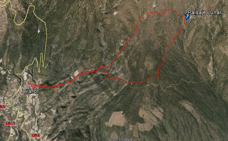
Path from Vilaflor to Lunar Landscape

Municipality: Vilaflor de Chasna
Aproximate time: 5h
Maximun Height: 1966m  (aprox)
Minimun Height: 1382m   (aprox)
Distance (Km): 12,4Km (aprox)


Area Information

On that ocassion we are inside the "La Corona Forestal"  (Forest Crown) that  belongs to the municipality of Vilaflor de Chasna (already in other publications, we have explained the characteristics of that kind of forest). Where the  Canary Pine is a great example of vegetation

The lunar landscape (known originally as The Escurriales is the point of interest in the route, though the route is enjoyed by it alone). These peculiar forms, which might be extracted of other planets, are due to the eruptions and the erosive agents as the wind, the rain, etc...

These forms are composed of ashes (a cup of volcanic ash after the eruptions) and pumitas (a kind or rock); being very vulnerable materials to the erosion, that with the years and the erosive agents have gone away eroded. For this motive the landscape is contemplated from a certain distance, due to the fragility of the same ones. And it is a duty and the rights of all of us are enjoying it and to preserve it for the enjoyment of all the generations.


The Lunar Landscape

Description of the path 


The drop of the path
We move up to Vilaflor's municipality, exactly we start the route from San's Pedro Church and Sanctuary of the Brother Pedro, the zone in which we find some Canary houses as paved street. Since to all the places, we can choose for the option to leave the car in the village, it has zone of parking or in the streets or to go on public transport, line 482 (from Arona to Vilaflor) and the line 34 (the Christians to the gap) TITSA.

We initiate the path from the back street to the Sanctuary (a building stone) and between a street where we find the shops (everything is opposite to the church). We take this street until the end and turn to the right, towards a reservoir (this part is lowered) and left hand we find the sign of path Vilaflor-Guajara. (That passes for Chasna's former way, the former route of communication between the north and the south of the island).

Sancturay of Brother Pedro

It is a path that is put up signs at all time, for what it has not possible of being lost in the zone (we are inside a path that is equivalent to a Small Tour and  to a Great Tour). The first part of the same one, since we leave the village, is in ascent and this one well delimited the way since we pass for different gardens or bench-covers that they find with walls. We do this first ascension from the village up to the forest track. This part is the only path, that is to say that does not have any bifurcation and to return to the village we descend to the same place.

In the forest track, we find the sign that continues indicating the path, we have to cross the track and come up to the following signs and raise some stairs. This part is to circulate, being able to choose the path that we begin and for which we end; since taking an option or another one we come to the same point ( These signs that we find at the end of a few steps justly on the forest track). In this case we took to right hand (and it was a success, since the slope is not so accused as the other option to be rising).


The first part of the path
The first part  is a bit flat ( we will have to take some slope, but without too many inclination) in almost the whole tour we see the forest track and in some occasion we have to take it to continue to take it in  the path. The last part of this section in which we come to the viewing-point of the Lunar Landscape has a bit of inclination, but without a major effort.

At the viewing-point of the Lunar Landscape, viewing-point of The Escurriales, we see an informative cartel, and the Lunar Landscape is to the other side of the ravine (before there was a path that was going to give the lower part of the landscape, but due to the explained in " Information on the zone ", already it is not possible). From the viewing-point we see two zones of concentration of these forms.


From the viewing-point

We continue the march of ascendant form during a few meters, up to coming to the maximum point of the slope in which we find again sign that indicates us Vilaflor, or if we continue rising we would come to Guajara (of here the explanation of that in the path we find sings that they indicate Small Tour and Great Tour to us, referring to the path that comes to "Las Cañadas", in this case up to Guajara).

From this point of signs we are descending, with some flat zone. Though to one of these points we go on in front of other peculiar formations very similar to those of the Landscape, where if we do not walk with precaution we can slip ourselves easily. After this point, we pass for an old house that this well to do a stop and to rest.


1. Forms similar to Lunar Landscape
2. The signs.

After a few meters getting down and leaving behind the house, we come to the point of signs, a few meters before the forest track . From this point, we cross again the forest track and get down to the same path that we come from the village.

The top of this path
The path in hot days becomes very hard, since the vegetation is not so dense and there is no many shades, and also to add that we are in the south zone of the island where the temperatures are high, especially in summer.

Forest track


lunes, 15 de junio de 2015

Vilaflor-Paisaje Lunar

Municipio: Vilaflor de Chasna
Duración aproximada del camino: 5h
Desnivel máximo: 1966m
Desnivel mínimo: 1382m
Distancia [Km]: 12,4 Km


Información sobre la zona


Nos encontramos dentro de la Corona Forestal que pertenece al municipio de Vilaflor de Chasna (ya en otras publicaciones, hemos explicado las características de la corona forestal). Teniendo como gran ejemplo de vegetación el Pino Canario.

El paisaje lunar (conocido originalmente como Los Escurriales es el punto de interés en la ruta, aunque la ruta se disfruta por si sola). Estas peculiares formas, que bien podrían ser sacadas de otros planetas, son debido a  las erupciones y los agentes erosivos como el viento, la lluvia, etc... 

Paisaje Lunar
Estas formas están compuestas por cenizas (una capa de ceniza volcánica tras las erupciones) y pumitas; siendo materiales muy vulnerables a la erosión, que con los años y los agentes erosivos se han ido erosionado (valga de redundancia). Es por este motivo que el paisaje se contempla desde una cierta distancia, debido a la fragilidad de los mismos. Y es un deber y derechos de todos disfrutarlo y conservarlo para el disfrute de todas las generaciones. 

Descripción del sendero 


Recorrido y mapa de elevación

Nos trasladamos hasta el municipio de Vilaflor, exactamente partimos la ruta desde la Iglesia de San Pedro y Santuario del Hermano Pedro, zona en la que encontramos algunas casas canarias al igual que calle adoquinada. Como a todos los lugares, podemos optar por la opción de dejar el coche en el pueblo (dispone de zona de parking o en los aparcamientos de las calles) o ir en transporte público, línea 482 (de Arona a Vilaflor) y la línea 34 (los cristianos al portillo) TITSA. 

Iniciamos el sendero por la calle trasera al Santuario (un inmueble de piedra) y entre una calle donde encontramos las tiendas (todo enfrente de la iglesia). Cogemos esa calle hasta el final y giramos a la derecha, en dirección a un estanque (esta parte es bajada) y a mano izquierda encontramos la señal de sendero Vilaflor-Guajara. (que transcurre por el antiguo camino de Chasna, antigua via de comunicación entre el norte y el sur). 

Iglesia
Es un sendero que se encuentra señalizado en todo momento, por lo que no hay perdida en la zona (estamos dentro de un sendero que equivale a un Pequeño Recorrido y a su vez a un Gran Recorrido). La primera parte del mismo, desde que dejamos el pueblo, es en ascenso y esta bien delimitado el camino ya que pasamos por diferentes huertas o bancales que se encuentran con paredes. Esta primera ascensión la hacemos desde el pueblo hasta la pista forestal. Esta parte es sendero único, es decir que no tiene ninguna bifurcación y para regresar al pueblo descendemos por este mismo lugar. 

En la pista forestal, encontramos la señal que sigue indicando el sendero, tenemos que cruzar la pista y llegamos hasta la siguiente señal y subimos unas escalera. Esta parte es circular, pudiendo elegir el sendero que empezamos y por el que terminamos; ya que cogiendo una opción o la otra llegamos al mismo punto (estas señales que se encuentran al final de unas escaleritas justo encima de la pista forestal). En este caso cogimos a mano derecha (y fue un acierto, ya que la pendiente no es tan acusado como la otra opción para ir subiendo).


Primera foto: vemos el sendero a través de las huertas.
Segunda foto: final del primer tramo, pista forestal
La primera parte es un poco llana (no quiere decir que sea totalmente, sino tendremos que coger alguna pendiente, pero sin demasiada inclinación) en casi todo el recorrido vemos la pista forestal y en alguna ocasión tenemos que cogerlo para continuar por el sendero. La última parte de este tramo en la que llegamos al mirador del Paisaje Lunar tiene un poco de inclinación, pero sin un mayor esfuerzo.

En el mirador del Paisaje Lunar, mirador de Los Escurriales, vemos un cartel informativo, y digo mirador ya que el Paisaje Lunar se encuentra al otro lado del barranco (antes había un sendero que iba a dar la la parte baja del paisaje, pero debido a lo explicado en "Información sobre la zona", ya no es posible). Desde el mirador vemos dos zonas de concentración de estas formas.


Primera foto: sendero hacia el Paisaje
Segunda foto: mirador del Paisaje
Continuamos la marcha de forma ascendiente durante unos cuantos metros, hasta llegar al punto máximo de la pendiente en la que encontramos de nuevo señales que nos indica Vilaflor, o si seguimos subiendo llegaríamos a Guajara (de aquí la explicación de que en el senderos encontramos señales que nos indican Pequeño Recorrido y Gran Recorrido, haciendo referencia al sendero que llega a las Cañadas, en este caso hasta Guajara). 

Punto alto del recorrido
Desde este punto de señales vamos descendiendo, con alguna zona llana. Aunque a uno de estos puntos pasamos delante de otras peculiares formaciones muy parecidas a las del Paisaje, donde si no andamos con precaución podemos resbalarnos fácilmente. Después de este punto, pasamos por una casa vieja que esta bien para hacer una parada y descansar. 


Primera foto: formación parecida al paisaje
Segunda foto: la casa para el descanso
Tras unos cuantos metros descendiendo y dejando atrás la casa, llegamos al punto de la señales, unos metros antes de la pista forestal .Y ya desde este punto, cruzamos de nuevo la pista forestal y descendemos por el mismo sendero que llegamos del pueblo. 

Vistas del Sur desde el sendero
El sendero en días de calor se hace muy duro, ya que la vegetación no es tan densa y no hay mucha sombra, y también añadir que estamos en la zona sur de la isla donde las temperaturas son más altas, sobre todo en verano. 

jueves, 21 de mayo de 2015

Signposting path

Already some paths have been published and still there remain great more. But in this occasion one will speak on the signposting of the same ones (rather a small summary).


Signs that indicate a path
In some publications it has been named like to continue the path that is described, many of which are put up signs and to certain distances it is found the signs that indicate the direction to continue. In other occasions, on the contrary, there is not put up signs and it is the own already made path the one that guides us (in the own soil); or a former plate of path where one sees the image of a dolly (a hiker with rucksack); or finally the stones put by previous hikers.

Signs of a path with numbers
In the beginning of the approved paths (that are those paths that are identified by the signs and authorized by the autonomous and / or territorial federation). Normally there is an informative panel, in which we can see the tour, distance, difference, information of interest ... and also there appear the signs and the meaning of the same ones.

Explanatory poster at the beginning of a path
This sign indicates the type of tour that we are going to realize; it is this "GR" Great Tour (red color), "PR" Small Tour (yellow color) ó "SL" Local Path (green color).These come identified by different colors (already above mentioned), and on occasions there are superposed two types of different paths (because a section of  Great Tour passes for a Small Tour or for Local Path; a section of Small Tour passes for a Local Path; etc). They indicate us the way that we must take, if we continue well, if we have been wrong, where we take the curve to, etc (these can be painted on rocks or in sticks).


The first image we have the informative panel, indicating in red
the zone where the signs are. The second image
 the signs extracted of the first image.

All this information remains reflected in the presentation (*) of FEDME (Spanish Federation of Sports of Mountain and Climbing, web page: http: // www.fedme.es/). In case of Canaries we have FECAMON (Canary Federation of Mountaineering, web page: http: // fecamon.es/).

(*) http://www.fedme.es/salaprensa/upfiles/294_F_es.pdf (link where the signs are explained, in Spanish)

Signs of a path, where this one it is a part of one Small Tour
and of Great Tour. 


Señalización de Senderos


Ya se han publicado algunos senderos y todavía quedan muchos más. Pero en esta ocasión se hablará sobre la señalizacion de los mismos (más bien un pequeño resumen). 


Señales indican sendero
En algunas publicaciones se ha nombrado como continuar el sendero que se está describiendo, muchos de los cuales están señalizados y a ciertas distancias se encuentran las señales que indican la dirección a seguir. En otras ocasiones, por el contrario, se han cogido caminos no señalizados y es el propio sendero ya hecho el que nos guía (en el propio suelo); o bien una antigua placa de sendero donde se ve la imagen de un muñequita (senderista con mochila); o por ultimo las piedras puestas por anteriores senderistas. 

Indicación de sendero con número
Al comienzo de los senderos homologados (que son aquellos senderos que están identificados por las señaleticas y homologados por la federación autonómica y/o territorial) normalmente hay un panel informativo, en que podemos ver el recorrido, distancia, desnivel, datos de interés... y también aparecen las señales y el significado de las mismas.

Cartel informativo a principio de sendero
Esta señales identifican el tipo de recorrido que vamos a realizar; sea este Gran Recorrido (color rojo), Pequeño Recorrido (color amarillo) ó Sendero local (color verde). Estos vienen identificados por diferentes colores (ya dicho), y en ocasiones se superponen dos tipos de senderos diferentes (porque un tramo de Gran Recorrido pasa por un Pequeño Recorrido o por Sendero Local; un tramo de Pequeño Recorrido pasa por Sendero Local; etc). Nos indican el camino que debemos tomar, si seguimos bien, si nos hemos equivocado, para donde cogemos la curva, etc (estos pueden estar pintados sobre rocas o bien en palos).


Primera imagen tenemos el panel informativo, señalando en rojo
la zona donde se encuentra la señalitca. Segunda imagen la
señaletica sacada de la primera imagen. 

Toda esta información queda reflejada en la presentación (*) de FEDME (Federación Española de Deportes de Montaña y Escalada, página web: http://www.fedme.es/). En el caso de Canarias tenemos FECAMON (Federación Canaria de Montañismo, página web: http://fecamon.es/) 

(*) http://www.fedme.es/salaprensa/upfiles/294_F_es.pdf  (enlace donde se explica la señaletica) 

Señales de sendero, donde este tramo es parte de un
Pequeño Recorrido y de un Gran Recorrido:


miércoles, 13 de mayo de 2015

La Guancha (En)

Municipality: La Guancha 


History


Before the conquest, it is thought that the aboriginal core should have placed in the environment of " The Fountains of the Guancha ", due to the abundance of springs. Near these births of water, along the municipality, they have found numerous findings, especially pieces of ceramics.

After the ending of the conquest in 1496, the lands of this zone were not covered completely, for the malpaíses (It is an accident of the relief characterized by the presence of rocks little eroded of volcanic origin in an arid environment). The only local settlers were some aborigines grancanarios (from Gran Canaria, to those who gave each other the first portions of lands for having helped in the conquest of Tenerife). With this accession there would be born the coastal neighborhood of Santa Catalina.

View from La Guancha

Between the cultures that were produced in the zone, the maize was, principally, followed by the wheat, potatoes and the grapevine. As for the handcrafted production, the market was for a local supply, as the greatest percentage of the cultures.

The population of the municipality was principally established in Santa Catalina and distributed in the field (but in minor number). The property of the land was divided between foreign, or small estates that were loaded with taxes (obligatory presentation). Nevertheless, the municipality saw a decrease of the population for facts as; the great alluvium of 1826; the intense deforestation (that was doing that the rains were turning into floods); and the crisis after the Napoleonic wars, originating a massive emigration, to places as Venezuela and the Greater Antilles.

Santa Catalina
With the arrival of new cultures, the return of the emigrants and other economic improvements that the island would suffer; it does that the municipality returns to increase in population (a fact that repeats itself along the whole island geography). 

Representative buildings 


Casco Antiguo de Santa Catalina (Old town of Santa Catalina): It was the first population nucleus of the zone, and in where we can find the hermitage constructed in 1510 by the first settlers, grancanarios, and reconstructed in 1867 due to the alluvium of 1826, which destroyed it largely.

In the surrounding areas, there are still some houses of Canary typology, exactly in the "calle real" royal way (today it is divided  into "camino real cañada baja" and "calle real"). It is emphasized between the casona (big house) of the Falcon family and the one built by Felipe Perez Rodríguez at the end of the XIXth, on two floors and of neoclassic style and adorned with hewn stone in the corners. 

One of the streets
Iglesia corazón de Jesús (Church Jesus' Heart): Of Mudejar style (It is an artistic style that develops in the Christian kingdoms of the Iberian peninsula, but that Hispanic - Muslim incorporates influences, elements or materials of style).  It is a building of 1579 as hermitage and before the increasing population wide in 1609 it was reformed as a parish. It is a church of two ships, separated by round arches and possesses a Mudejar roof.

In the interior we find altarpieces of the 18th century and pieces and images of great artistic and historical value.

Door

Taller de Artesanía (Workshop of Crafts):It was born from the good acceptance that it had the Fair of Crafts of the municipality in all the editions. The birth was the result of the union of the neighboring craftsmen who up to this moment were dispersed for the municipality and for what could get lost some of the handcrafted modalities.

It possesses a varied range of rooms where it is elaborated and the samples of pottery are exposed, raffia, basket-making, fret, loom, etc.

Workshop

Bodegas (cellar): one of the places that to visit and where to prove wine one of the zone. Many of them are found by us in former Canary houses.

Vineyard
Since always, we mention some of the heritages of each municipality, in this case we have centred on the old town of Santa Catalina (as core) and some more representative real estate. But we never forget that along the whole geography of the municipality we find samples of real estate of Canary typology preserved well and that they must be visiting.


Old Hauses

martes, 14 de abril de 2015

La Guancha


Municipio: La Guancha


Historia 

Antes de la conquista, se cree que el núcleo aborigen debió situarse en el entorno de "Las Fuentes de la Guancha", debido a la abundancia de manantiales. Cerca de estos nacimientos de agua, a lo largo del municipio, se han encontrado numerosos hallazgos, sobre todo piezas de cerámica.

Tras la finalización de la conquista en 1496, las tierras de esta zona no fueron codiciadas del todo, por sus malpaíses. Los únicos pobladores del lugar fueron algunos aborígenes grancanarios (a los que se les dieron las primeras porciones de tierras por haber ayudado en la conquista de Tenerife). Con este asentamiento nacería el barrio costero de Santa Catalina (ermita vinculada a la evangelización grancanaria). 

Entre los cultivos que se producían en la zona, el millo era el principal, seguido del trigo, las papas y la vid. En cuanto a la producción artesanal, su mercado era para un abastecimiento local, al igual que el gran porcentaje de sus cultivos.

Desde la TF-342
La población del municipio se encontraba principalmente en Santa Catalina y repartidos por el campo (pero en menor número). La propiedad de la tierra estaba dividida entre foráneos, o pequeñas fincas que se encontraban cargadas de tributos (prestación pecunaria obligatoria). Sin embargo, el municipio ve una disminución de su población por hechos como; el gran aluvión de 1826; la intensa deforestación (que hacía que las lluvias se convirtieran en riadas); y la crisis después de las guerras napoleónicas, originando una emigración masiva, a lugares como Venezuela y las Grandes Antillas.

Con la llegada de nuevos cultivos, el retorno de los emigrantes y demás mejoras económicas que sufriría la isla, hace que el municipio vuelva a aumentar en población (hecho que se repite a lo largo de toda la geografía isleña).

Antigua Casa en La Guancha (núcleo poblacional)

Inmuebles a Visitar

Casco antiguo de Santa Catalina: Fue el primer núcleo poblacional de la zona, y en el podemos encontrar la ermita construida en 1510 por los primeros pobladores, grancanarios, y reconstruida en 1867 debido al aluvión de 1826, que la destruyó en gran parte.

En las inmediaciones, nos encontramos todavía algunas casas de tipología canaria, exactamente en la camino real (hoy dividido entro camino real cañada baja y calle real). Se destacan entre ellas la casona de la familia Falcón y la edificada por Felipe Pérez Rodríguez a finales del XIX, de dos plantas y de estilo neoclásico y adornada por cantería en las esquinas.

Ermita de Santa Catalina
Iglesia Corazón de Jesús: De estilo mudéjar es una edificación de 1579 como ermita. Ante la creciente población se amplia en 1609. Es una iglesia de dos naves, separadas por arcos de medio punto y posee una techumbre mudéjar. 

En el interior encontramos retablos del siglo XVIII y piezas e imágenes de gran valor artístico e histórico.

Iglesia Corazón de Jesús
Taller de Artesanía: se crea a partir de la buena aceptación que tuvo la Feria de Artesanía del municipio en todas sus ediciones. Su nacimiento fue el resultado de la unión de los vecinos artesanos que hasta ese momento se encontraban dispersos por el municipio y por lo que se podía perder algunas de las modalidades artesanales.

Posee una variada gama de salas en donde se elaboran y se exponen las muestras de alfarería, rafia, cestería, calado, telar, etc.

Taller de Artesanía

Bodegas: uno de los lugares que visitar y donde probar vino de la zona, son sus bodegas, muchas de ellas las encontramos en antiguas casas canarias.

Viña
Como siempre, mencionamos algunos de los patrimonios de cada municipio, en este caso nos hemos centrado en el Casco de Santa Catalina (como núcleo) y algunos inmuebles más representativos. Pero nunca nos olvidamos que a lo largo de toda la geografía del municipio encontramos muestras de bienes inmuebles de tipología canaria bien conservados y que merecen la pena visitar.