lunes, 5 de mayo de 2014

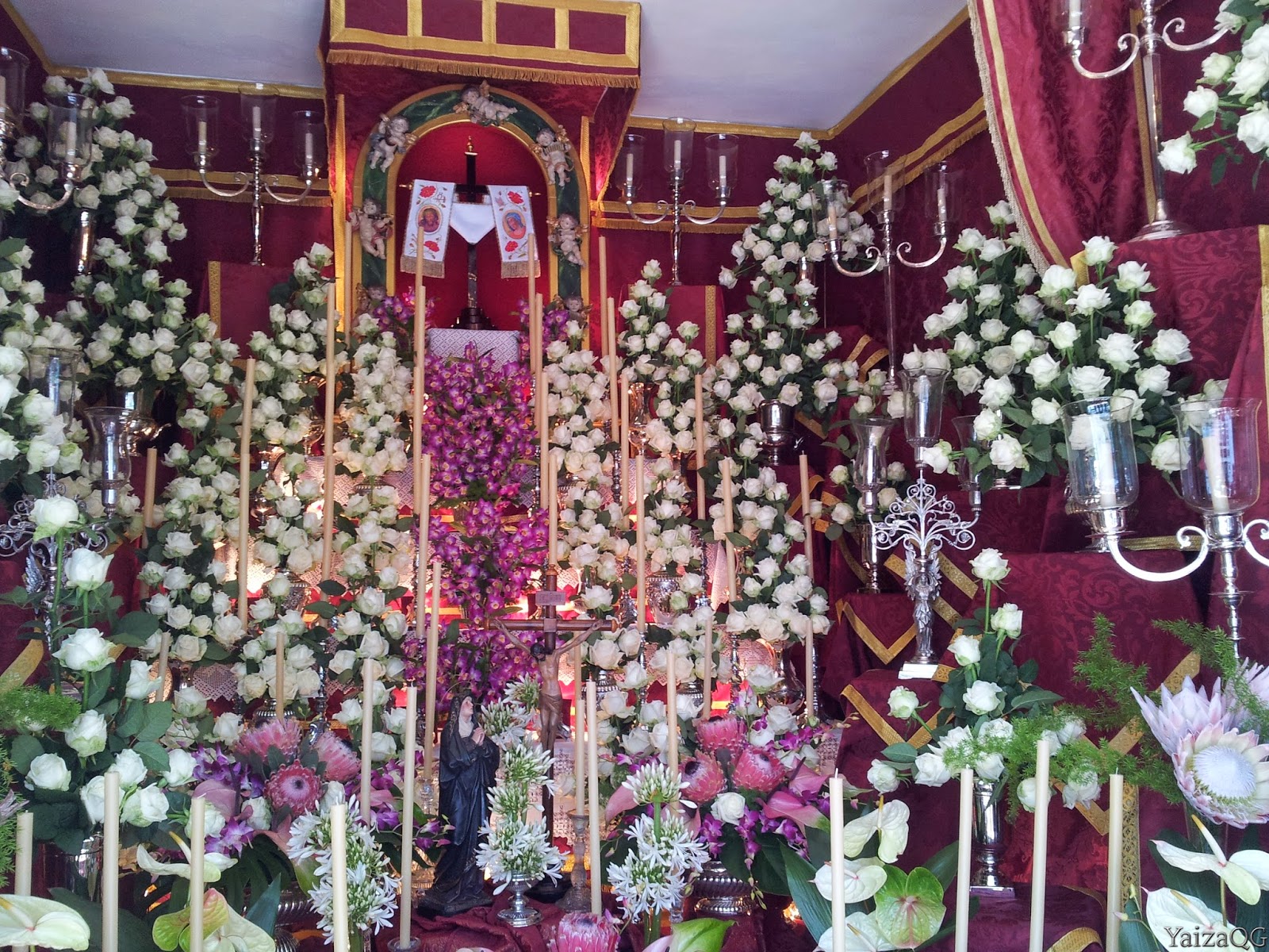
Cruz de Mayo y Fuegos

Municipio: Los Realejos


Hoy vamos a hablar sobre "Las Cruces y Fuegos de Mayo". Esta fiesta fue declarada Bien de Interés Turístico en el año 2009 (este fue el primer municipio de Canarias en obtener este reconocimiento ya que esta denominación apareció en el año 2008) debido a la importancia para el municipio y por las miles de visitas que recibe el pueblo en estos días, no sólo de la isla y residentes nacionales, sino también turistas extranjeros.

La fiesta de La Cruz se celebra en muchos países y también muchas regiones de España. El nacimiento de esta festividad es algo dudoso, pero se cree que es raíz de la cruz en la que murió Jesús y fue encontrada por Santa Elena en el año 326 D.C, desde esta fecha la Iglesia Católica ha conmemorado el 3 de mayo como día de la Cruz. Pero nosotros vamos a contar, también entre teorías, el arraigo de estas fiestas en la isla, sobre todo en Los Realejos. Por ser fiesta de la cruz, también se celebran en los municipios que llevan tal nombre, como Santa Cruz (capital de la isla) y que lo celebra junto a la conmemoración de la fundación de la ciudad en 1949, en el Puerto de la Cruz, etc.

Ruta de Las Cruces este año 2014
Como todo, se hacen varias hipótesis del nacimiento de esta festividad. Una de ellas tiene que ver con la cruz de madera que se puso después de la conquista, lugar en el que hoy se encuentra la Parroquia del Apóstol Santiago, que es el primer templo cristiano de la isla. Otra se debe a todas las cruces que se encuentran en el municipio, colocados por los frailes en las zonas alejadas del casco. Hay que decir, que la cruz es uno de los símbolos cristianos, y en otros tiempo no había casa o lugar en la que no se pusiera. Siendo este día, como se ha mencionado, día de veneración de la misma.

Dentro del municipio existen tres focos que concentran las miradas esos días, La Calle del Sol y la del Medio y La Cruz Santa. Este último debe el nombre, según la leyenda, a que en el barranco un hombre encontró una cruz de plata, que hoy en día está en la parroquia de este lugar, de ahí el nombre del pueblo.

Cruz
En cuanto a la calle del Sol y la del Medio, son dos calles que tienen una larga historia de disputas entre ellas. La calle del Medio es donde residían los marqueses mientras que el la calle del Sol la de los medianeros y pequeños campesinos, hoy en día no existe tal diferencia debido a la evolución de la economía en la isla, pero si ha quedado entre nuestros días ese pique histórico con motivo de fiesta. Al parecer, y según algunos estudios, el pique comienza en 1770, cuando se sacaba en procesión a la cruz este día (aparte de ser símbolo cristiano, es el primer símbolo que se venera en la isla ya que los santos y demás símbolos se irán incorporando con el tiempo). Al paso de la procesión de la cruz por ambas calles, esta era celebrada con hogueras, humos de colores y haciendo mucho ruido para ver cuál era la calle que ganaba ese año. Hoy en día esta procesión se sigue dando en estas dos calles, subiendo por la del Sol y bajando por la del Medio. Aunque este pique haya dejado de lado el hecho religioso, es todo un espectáculo ver los fuegos iluminando los cielos del municipio.

Fuegos artificiales (la foto no es muy buena, pero es para explicar)
Para pagar estos fuegos, los vecinos trabajan todo el año. Este día tiene protagonismo dos grandes pirotecnias, Los Hermanos Toste y la Caballer. Durante más de dos horas, el cielo queda iluminado con estos fuegos, que se considera la mayor exhibición pirotécnica de España.

Las cruces se adornan, sobre todo con flores, aunque en los adornos se pueden incorporar diferentes materiales. En épocas anteriores, este día los vecinos sacaban sus cruces y las adornaban, en modo de pique de cuál era la más bonita. Aunque hoy en día el pique se sigue manteniendo, dan premio a las mejores cruces, es un pique sano en el que lo que se trata es de disfrutar adornándolas y que los visitantes disfruten viéndolas. 

Una de las Cruces
También mencionar, y no menos importante, la cruz que se encuentra encima de la Montaña de los Frailes. También en esta fecha, la cruz que se encuentra en la capilla, es sacada en procesión, estando durante todo el día la capilla abierta, y los vecinos encargados de la celebración ( un año vecinos de la higuerita y otro año de la montaña) dan comida a los visitantes que ese día suben la montaña para ver esta cruz.

Hemos nombrado estos puntos ya que son los que mas focos de gente atraen durante esos días, sin embargo a lo largo de todo el municipio, existen cruces que son enramadas por sus dueños pudiendo ser visitadas.

Cruz


miércoles, 23 de abril de 2014

Casco de la Orotava (Town of La Orotava)

Municipality: La Orotava


History


We are in El Valle de la Orotava (the Valley of the Orotava), which is composed of the municipalities of La Orotava, Los Realejos and Puerto de la Cruz. This time we are going to know El Casco de la Orotava (The town) that is one of the old tows better preserved of the island.

Before the conquest the municipality was concerned to the Menceyato de Taoro (ancient kingdoms formed by the ancient inhabitants of the island). The name of the municipality  is unknown wherefrom it comes. Some historians think that the name comes from Arautava or Arautápala, which is since The Original inhabitants of the island were named to this zone. Nevertheless others hold that it comes from Taoro, which was since original inhabitant of the island was called to this kingdom, for what we are before Taoro's Valley. But this theory holds that there would be a change of letters and putting the suffix - va goes (Taoro+va = Orotava).

After the conquest, the land was distributed between friends and family of Alonso Fernandez of Lugo, this fact originated several conflicts. This zone was one of the most demanded since they were fertile lands and it was possessing rich springs especially in Aguamansa (high zone of the municipality). The neighbors continued complaining, before the disproportionate distribution of lands, as a consequence a documentation is realized.

One of the street
 In 1503 the official accession of the core is realized, where some lots were destined for cultivation. This accession was concerning the streets and to the housings, mills, sawmills and existing ingenuities, though the new constructions had to have the same measures (houses) and it had to leave a considerable width of the roads. This accession and its streets were realized concerning La Iglesia de la Concepción (the hermitage of the Concepcion) , this way growing up to the 17th century, century of maximum brilliance of the Villa. The image of the people remains framed between the ravines and the marked difference of the area.

This core was growing towards the south, known as the Villa de Arriva (Above), less suitable lands for the culture, for what in them there established peasants, craftsmen, etc. In the zone we were meeting a marked inequality, being in the center the most powerful families and in the surroundings the poorest. This fact is reflected in the houses, in its hermitages (the Villa de Abajo (below) had La Iglesia de la Concepción, (the Church of the Concepcion), The Villa de Arriba (Above) La Iglesia de San Juan Bautista (Church of San Juan Baptizer), etc.

The first cultivation is the sugar cane, which needed the Sun and water, for what the owners of the best lands were favored. Already in the year 1503 (year of establishment of the town) they were possessing regulatory ordinances of the water. For the irrigation there were constructed drainpipes that take the water up to the coast and they were happening in the town to supply the neighbors. This one was led thanks to the hydraulic power of the mills.

Canary houses, Drago and Palm
 Substituting the plantation of the sugar cane (it fell down when it was begun to cultivate in South America, it was possible to cultivate big extensions of land, for what its plantation was more profitable instead of the produced one in the islands) the wine appears, putting in the head of export of Malvasias (a Sweet wine elaborated, strong white, sweet, fragrant wine and of high graduation.

Thanks to this plantation, La Orotava grows so much socially as economically. This fact remains reflected when the municipality was named as an Extensive Villa in the 17th century, which it propitiated the judicial independence possessing a mayor or judge of the first stay. Though administratively and politically it continued concerning to La Laguna up to the 19th century. This fact turns La Orotava into the first municipality freed of La Laguna.

The malvasía wine entered in decadence, and also it was done by the social and economic development of the zone. From this moment several cultivations were implanted, but especially for the subsistence. Between epochs of growth, epochs of decline come, since everything depends on the new plantations. At the ends of the XIXth and the beginning of the XXth the banana was entered, for what there was an economic growth that remains paralyzed by the different conflicts in the continent.

Street near of the Town Hall
 With the arrival of the tourism to the island, this municipality had benefited by the nearness to  El Puerto de la Cruz, devoting itself the population to the construction and services sector. But this fact, the image of the town was not modified as if it happened in other municipalities, being able to enjoy at present these constructions.

The town of La Orotava was declared as an  Historical place since 2004, and we can find some building declared as Bien Interés Cultural.(a protection of some building that are important for the history and the population).

Representative Buildings


Molino de Agua (Water mills):  nowadays there are just 9 of 13 that exited. It is possible to realize a route that visits 9 mills. They were used to lead the water, but also with this movement propitiated by the water, the cereals are ground to do the Gofio(a cereal). In 3 of these mills there can be bought this typical and basic food of the Canary supply.

Parroquia Nuestra Señora de la Concepción (Church Our Lady of the Concepcion): the hermitage was raised in 1498, but diverse works and extensions were attacked, especially in the year 1632. In 1704, a new reform was realized due to the fact that the earthquakes of Güimar's volcano originated serious hurts in the same one. It is a temple of baroque style, possesses two towers with a series of arches. The front page possesses pilasters with capitals on it. The church has three ships separated by Ionic columns and Corinthian capitals.

The Church of Nuestra Señora de la Concepción
Casa Lercaro  (Lercaro´s house): the real name of the house is of  Ponte-Fonte, though it is known more for the following owners, Los Lercaro, a family that was moving from La Laguna to La Orotava. It was constructed in 1654. In the main face one sees the trimmings esgrafiadas, and the carpentry in balconies and window. There are inside a bar and a furniture shop.

Lercaro´s house

Hijuela del Botánico (it is a kind of Botanist garden, with was originally an orchard of a convent): it is a space of 3.390m ², located in the behind part of the Town hall. The enclosure is surrounded by a wall of the 19th century, of masonry, with grating and front page. This one was the former garden of the clariso of San Jose convent. Among the species that it is found, fit to stand out the members of the Canary flora, among them the Drago, el Cedro, the Canary Pine, el madroño, etc.

Hijuela del Botánico
 El Ayuntamiento (The Town Hal)l: the building was constructed at the end of the 16th century, being in previous epochs the Convent of San Jose. It is of neoclassic style with linear and symmetrical front. The door is inside of a portico and the building is finished with a triangular fronton with the shield of the Villa.

Town Hall
 La Casa de los Balcones (The House of the Balconies): the municipality is known by its balconies, between them one of the houses exploited as a tourist place is The House of the Balconies. The Building dates back of the XVIIth and XVIth century, it is underlined its balconies and the central the yard. The front has three floors possessing a traversed balcony on the top. It is possible to visit the interior, being in the second plant a museum that counts the life in the house. Apart from souvenirs, also it is possible to find a great sample of soaking and other typical products.

La Casa de los Balcones
Liceo Taoro (it is a society called Liceo Taoro, but we are going to describe the house): it is a building that begins its construction in the first part of the 20th century. It has an eclectic style and the building is at the high of a few stairs. Constructed by a couple of just married, in 1975 the company Liceo Taoro acquired it. The same one can be visited, since it is found a restaurant and a bar on the first floor. Occasionally exhibitions of art are displayed, for what it is possible to visit the instances of the second floor.

Liceo Taoro
 Iglesia de San Juan Bautista (San Juan Baptizer Church): since already it has been mentioned before, in the first moment La Orotava was divided between La Villa de Arriba and La Villa de Abajo, the center of the town. In La Villa de Arriba the poorest population was living, and one of the examples is its Church, which was constructed with poorer materials, opposite case of La Parroquia de la Concepción. The church began to be built in the 17th century, being constructed on the former hermitage, of which only part of the front page remained. The front is Renaissance, an only a tower. It possesses an only ship of the Latin cross and two lateral chapels. The current building dates back to 1728, when it carries out its reconstruction. In one of its wings it possesses a balcony of  tea (a kind of wood).

The Church of San Juan

Apart from all the real estate named, there remain great for visiting. The center of the town can be crossed walking and to estimate the different architectural forms, as well as it is a street of cobbles. Many of the real estate can be visited, since nowadays they are museums, houses of souvenir, hotels, restaurants, etc. Between them we can name, El Jardín Victoria ( The Victory Garden), La Iglesia de Santo Domingo de Guzmán (the Church of Santo Domingo de Guzmán) and San Benito's Ex-convent, San Agustín's Church and Ex- convento de Nuestra Señora de Gracia (Ex-convent of Our Lady of Grace), etc. The best form of visiting is going in person.

We have mentioned only the center, the municipality possesses a wide variety of buildings distributed between its population cores, as well as theme parks, paths, restaurants, guachinches (place where it is possible to eat and to drink wine from the island), etc.

Some Canary houses in La Orotava


viernes, 11 de abril de 2014

Casco de la Orotava


Municipio: La Orotava

Historia


Nos encontramos en el Valle de la Orotava, compuesto por los municipios de La Orotava, Los Realejos y el Puerto de la Cruz. Esta vez vamos a conocer el Casco de la Orotava, que es uno de los cascos mejor conservados de la isla.

El municipio antes de la conquista pertenecía al Menceyato de Taoro. El nombre del muncipio no se sabe muy bien de donde procede. Algunos historiadores consideran que el nombre viene de Arautava o Arautápala, que es como denominaban Los Guanches a esta zona. Otros, sin embargo sostienen que viene de Taoro, que era como se llamaba a esta zona en la época guanche, por lo que nos encontramos ante el Valle de Taoro. Pero esta teoría sostiene que habría un cambio de letras y poniendo el sufijo -va (Taoro+va= Orotava).

Tras la conquista, se hace el reparto de tierras, que dio lugar a varios conflictos, ya que el reparto se vio beneficiado para los familiares y amigos de Alonso Fernández de Lugo. Esta zona fue una de las más demandadas ya que eran tierras fértiles y poseía ricos manantiales sobre todo en Aguamansa (zona alta del municipio). Los vecinos se siguieron quejando, ante el desproporcionado reparto de tierras, por lo se realiza una documentación.

La Orotava

En 1503 se realiza el asentamiento oficial del núcleo, en donde algunos solares estaban destinados a cultivos. Este asentamiento se hizo en torno a las carreretas y a las viviendas, molinos, aserraderos e ingenios existentes. Aunque las nuevas construcciones debían tener las mismas medidas (casas) y se debía dejar una anchura considerable para las carreteras. Este asentamiento y sus calles se realizaron en torno a la ermita de la Concepción, así creciendo hasta el siglo XVII, siglo de máximo esplendor de la Villa. La imágen del pueblo queda enmarcada entre los barrancos y el acentuado desnivel del terreno.

Este núcleo fue creciendo  hacia el sur, conocido como la Villa de Arriba, tierras menos aptas para el cultivo, por lo que en ellas se establecieron campesinos, artesanos, etc. En la zona nos encontrábamos con una marcada desigualdad, estando en el casco las familias más poderosas y en los alrededores los más pobres. Este hecho se ve reflejado en las casas, en sus ermitas (la Villa de Abajo tenía la Iglesia de la Concepción, La Villa de Arriba la Iglesia de San Juan Bautista), etc.

Calle adoquinada
El primer cultivo es la caña de azúcar, que necesitaba sol y agua, por lo que los propietarios de las mejores tierras se vieron favorecidos. Ya en el año 1503 (año de establecimiento del núcleo) poseían ordenanzas reguladoras del agua. Para el riego se construyen atarjeas que llevan el agua hasta la costa y pasaban por el casco para abastecer a los vecinos. Esta era conducida gracias a la fuerza hidráulica de los molinos.

Sustituyendo al cultivo de la caña de azúcar (cayó en decandencia cuando se comienza a cultivar en América del Sur, se podía cultivar grandes extensiones de tierra, por lo que era más rentable su cultivo en vez del producido en las islas) aparece el vino, poniéndose en la cabeza de exportación de vinos malvasía.

Gracias a este cultivo, la Orotava crece tanto social como económicamente. Este hecho queda reflejado cuando es nombrada Villa Extensa en el siglo XVII, lo que propició la independencia judicial contando con un alcalde mayor o juez de primera estancia. Aunque administrativamente y políticamente siguió perteneciendo a La Laguna hasta el siglo XIX. Este hecho convierte a La Orotava en el primer municipio independizado de La Laguna.

El malvasía entra en decadencia, y también lo hizo el desarrollo social y económico de la zona. A partir de este momento se implantan varios cultivos, pero sobre todo para la subsistencia. Entre épocas de crecimiento, llegan épocas de declive, ya que todo depende de los nuevos cultivos. Finales del XIX y principios del XX se introduce el plátano, por lo que hay un crecimiento económico que queda paralizado por los diferentes conflictos en el continente.

Calle del Ayuntamiento
Con la llegada del turismo a la isla, este municipo se vio beneficiado por la cercanía al Puerto de la Cruz, dedicándose la población a la construcción y sector servicios. Pero este hecho no hace que se modifique la imagen del casco como si ocurriera en otros municipios, pudiendo disfrutar en la actualidad de esas construcciones.

El casco de la Orotava es un Conjunto Histórico desde 2004, y dentro del mismo podemos encontrar algunos inmuebles declarados Bien de Interés Cultural.

Inmuebles a Visitar


Molinos de Agua: de los treces que había sobre el año 1813, actualmente se conservan 9. Es posible realizar una ruta que visita los 9 molinos. Fueron usados para conducir el agua, pero también con ese movimiento propiciado por el agua, se muelen los cereales para hacer el Gofio. En 3 de estos molinos se pueden comprar este alimento típico y básico de la alimentación canaria.

Iglesia Nuestra Señora de la Concepción: la ermita se erigió en 1498, pero se acometieron diversas obras y ampliaciones, sobre todo en el año 1632. En 1704, se realiza una nueva reforma debido a que los terremotos del volcán de Güimar originaron graves daños en la misma. Es un templo de estilo barroco, posee dos torres con arquería. La portada posee pilastras con capiteles sobre ella. La iglesia es de tres naves separadas por columnas jónicas y capiteles corintios. 


Parroquia de Nuestra Señora de la Concepción
Casa Lercaro: el nombre real de la casa es de los Ponte-Fonte, aunque se conoce más por los siguientes propietarios, Los Lercaro, una familia que se traslado de la Laguna a La Orotava. Fue construida en 1654. En la fachada principal se ve las cenefas esgrafiadas, y la carpintería en balcones y ventanas. Hoy en día se puede visitar su inteor, ya que en las plantas superiores se encuentra una tienda de muebles, y en los jardines y primera planta un bar.

Casa Lercaro
Hijuela del Botánico: es un espacio de 3.390m², localizado en la parte de atrás del Ayuntamiento. El recinto se encuentra rodeado por un muro del siglo XIX, de mampostería, con reja y portada. Este era el antiguo huerto del convento clariso de San José. Entre las especies que se encuentran, caben destacar las integrantes de la flora canaria, entre ellas el Drago, el Cedro, el Pino Canario, el madroño, etc. 

Hijuela
El Ayuntamiento: el edificio fué construido a finales del siglo XVI, estando en épocas anteriores el Convento de San José de las Monjas Clarisas. Es de estilo neoclásico con fachada lineal y simétrica. La puerta se encuentra dentro de un pórtico y el edificio queda rematado con un frontón triangular con el escudo de la Villa. 

Ayuntamiento
 La Casa de los Balcones: el municipio es conocido por sus balcones, entre ellos una de las casas explotada turísticamente es La Casa de los Balcones. Edificio data de los siglos XVII y XVI, de el destacan sus balcones y el patio centran en el interior del inmueble. La fachada es de tres plantas poseyendo un balcón corrido en la parte superior. Se puede visitar su interior, estando en la segunda planta un museo que cuenta la vida en la casa. Aparte de souvenires, también se puede encontrar una gran muestra de calada y demás productos típicos.

Casa de los Balcones
Liceo de Taoro: es un edificio que comienza su construcción en la primera parte del siglo XX, es de estilo eclético y se encuentra en lo alto de unas escalinatas. Construido por unos recien casados, en 1975 la sociedad Liceo de Taoro lo adquiere. El mismo se puede visitar, ya que se encuentra un restaurante y un bar en la primer planta. De vez en cuando alberga exposiciones de arte, por lo que es posible visitar las instancias de la segunda planta.

Liceo de Taoro
Parroquia de San Juan Bautista: como ya se ha nombrado, en un primer momento La Orotava se encontraba dividida entre la Villa de Arriba y la Villa de Abajo, el casco. En la de arriba vivía la población más pobre, y uno de los ejemplo es esta Iglesia, la cuál fue contruidas con materiales más pobres, caso contrario de la Iglesia de la Concepción. La Parroquia de San Juan Bautista comenzó a edificarse en el siglo XVII, construyendose encima de la antigua ermita, de la que sólo se conservó parte de la portada. La fachada es renacentista, posee una sola torre campanario. Posee una sola nave de cruz latina y dos capillas laterales. El edificio actual data de 1728, cuando se llevo a cabo su reconstrucción.En uno de sus laterales posee un balcón de tea.

Parroquia de San Juan Bautista

Aparte de todos los inmuebles nombrados, quedan muchos por visitar. El casco se puede recorrer caminando y apreciar las diferentes formas arquitectónicas, así como su calle de adoquines. Muchos de los inmuebles se pueden visitar, ya que hoy en día son museos, casas de souvenir, hoteles, restaurantes, etc.  Entre ellos nombramos,  Los Jardines Victoria, Parroquia de Santo Domingo de Guzmán y Ex-convento de San Benito, Iglesia de San Agustín y Ex-convento de Nuestra Señora de Gracia, etc. La mejor forma de conococerlos, es visitándolos en persona. 

Aunque se nombre solo el casco, el municipio posee una amplia variedad de inmuebles repartidos entre sus núcleos poblacionales, así como parques temáticos, red de senderos, restaurantes, guachinches, etc.

Fuente (en una de las entradas al Casco)

martes, 1 de abril de 2014

Charcas de Erjos (Erjos´ pool)


Municipality: El Tanque
Aproximate time: 2h
Maximun Height: 1187 m (from sea level)
Minimun Height: 1020m (from sea level)
Distance (Km): 2,87 (one-way)


Area Information

We are in Teno's Rural Park. Las Charcas de Erjos (Erjos's Pools)  were extractions of arid and land between the 70s and 80s of the 20th century to be moved to the plantations of the south and north of the island. For its clayey character they have been transformed into natural warehouses of water of rain. It turns them into one of the scanty zones of interior capable of sheltering aquatic species.

Finished the extractions, about 20 years ago a great quantity of vegetable and animal species have been colonizing gradually the pools, though its presence is determined by the rains, for what the pools can remain semi-dry during long periods of time. 

On of Las Charcas (pools)

In these pools the vegetable species of major freightage is the Sauce Canario (Salix canariensis) existing others as the Tabacos (Typha domingensis), Juncos (Juncus efussus) and Carrizos(Cyperus eragrostis). Also Helechos (ferns), Zarzas (brambles), Tagasastes, etc

But undoubtedly, the most spectacular protagonists of the pools is the fauna, in it make concrete the birds tied to the aquatic way. Between them it is emphasized la Gallina Común (Gallinuela chloropus), which presence is stated from the 80s, la Focha Común (Fulica atra), La Agachadiza común (Gallinago gallinago) and La Garza Real (Ardea cinerea). Other birds related to the aquatic way which are more irregular to see  the Alpispa or Lavandera cascadeña (Motacilla cinerea canariensis), El Archibebe Claro (Tringa nebularia) and El Guincho o Äguila Pescadora (Pandion haliaetus) which can see in some occasions, especially when the evil being of the sea impedes the food search.

A Bird

It is necessary to highlight, that the pools are an obliged step of the migratory birds, which are in our lands a suitable place where to spend the raw winters of Europa's north.


Description of the Path


The drop of the Path

Elevation of Charcas de Erjos

Elevation of Cumbre el Bolico

Before explaining the tour, saying that in the map, the green route passes across the pools, and the red route goes towards Cumbre el Bolico (Bolico mountain top).

We begin the route in the entry that is opposite the bar (a solitary bar in all this section of road that it connects with Santiago del Teide, next to same it is a bus stop (The treatment with us was of antipathetic), the line is 360 (from Icod to Puerto de Erjos).To come to the same one, it is possible to come with public transport and with own car. The parking is scanty, but there are zones of the road  where it expands and it is possible to stop. (The parking of the bar, it is exclusive of these, though it stops parks who they wanted).

The Path
The path is partially put up signs, since in the same pools it is possible to take several routes of paths and estimate them from different points of view. Though it does not have a loss, since the way is well delimited.


In this case we did the route that connects with the path of  Monte del Agua and moved back towards same.

Then we took the path that is going to give to Cumbre el Bolico, where it is possible to see the set of Las Charcas (the pools)  with the Teide of bottom. On having finished this path in constant ascension, we come to the place from where we can estimate Santiago del Teide.

El Teide
 On having finished we go out to the same site, since the return was for the same route.

It is possible to do the route of  Las Charcas (the pools) only visiting the same ones, or it is possible to accede across several paths that go across for the zone.

This time Las Charcas (the pools) were full enough, since the rains during great winter part have been abundant. As for the vegetation it was slightly scanty, since still the zone is recovering of the fire happened in 2012.

Las Charcas de Erjos


viernes, 28 de marzo de 2014

Charcas de Erjos


Municipio: El Tanque
Duración aproximada: 2 horas
Altura Máxima:1187 metros (desde nivel del mar)
Altura Mínima: 1020 metros (desde nivel del mar)
Distancia (KM): 2,87 Km (ida)


Descripción de la zona


Nos encontramos dentro del Parque Rural de Teno. El Paraje de los Dornajos “Charcas de Erjos”, fueron extracciones de áridos y tierra entre los años 70 y 80 del siglo XX para ser trasladados a las plantaciones del sur y norte de la isla. Por su carácter arcilloso se han transformado en depósitos naturales de agua de lluvia. Ello las convierte en una de las escasas zonas de interior capaces de albergar especies acuáticas.

Finalizadas las extracciones, hace alrededor de 20 años, gran cantidad de especies vegetales y animales han ido colonizando paulatinamente las charcas, aunque su presencia está condicionada por las lluvias, por lo que las charcas pueden permanecer semisecas durante largos periodos de tiempo.

En estas charcas la especie vegetal de mayor porte es el sauce canario (Salix canariensis) existiendo otras como los tabacos (Typha domingensis), los juncos (Juncus efussus) y los carrizos (Cyperus eragrostis). También helechos, zarzas, tagasastes, etc

Una de las Charcas
Pero sin duda alguna, las más espectaculares protagonistas de las charcas es la fauna, en concreto las aves ligadas al medio acuático. Entre ellas destacan la gallineta común (Gallinuela chloropus), cuya presencia se constata desde los años 80, la focha común (Fulica atra), la agachadiza común (Gallinago gallinago) y la garza real (Ardea cinerea). Otras aves relacionadas con el medio acuático que suelen avistarse de forma más irregular son la alpispa o lavandera cascadeña (Motacilla cinerea canariensis), el archibebe claro (Tringa nebularia) y el guincho o águila pescadora (Pandion haliaetus) que se puede ver en algunas ocasiones, sobre todo cuando el mal estado del mar dificulta la búsqueda de alimento.

Cabe resaltar, que las charcas son además paso obligado de las aves migratorias, que se encuentran en nuestras tierras un lugar idóneo donde pasar los crudos inviernos del norte de Europa.

Descripción del sendero

Elevación Charcas de Erjos
Elevación Cumbre Bolico

Antes de explicar el recorrido, decir que en el mapa, la ruta verde discurre a través de las charcas, y la ruta roja va hacia Cumbre el Bolico.

Comenzamos la ruta en la entrada que se encuentra enfrente del bar (un bar solitario en todo ese tramo de carretera que conecta con Santiago del Teide, al lado de mismo se encuentra una parada de guagua, línea 360 (desde Icod hasta Puerto de Erjos). El trato con nosotros fue de antipáticos). Para llegar al mismo, se puede llegar con transporte público y con coche propio. El aparcamiento es escaso, pero hay zonas de la carretera donde esta se ensancha y se puede dejar. (El aparcamiento del bar, es exclusivo de estos, aunque deja aparcar a quién ellos quieran).

El sendero se encuentra parcialmente señalizado, ya que en las mismas charcas se puede tomar varias rutas de senderos y apreciarlas desde diferentes puntos de vista. Aunque no tiene perdida, ya que el camino se encuentra bien delimitado.

En este caso hicimos la ruta que conecta con el sendero del Monte del Agua y retrocedimos hacia las misma.

Inicio del sendero

Luego cogimos el sendero que va a dar a la Cumbre Bolico, donde se puede ver el conjunto de las charcas con el Teide de fondo. Al finalizar este sendero en ascensión continua, llegamos al lugar desde donde podemos apreciar Santiago del Teide. 

Al finalizar salimos por el mismo sitio, ya que la vuelta fue por la misma ruta.

La ruta de las Charcas se puede hacer sólo visitando las mismas, o se puede acceder a través de varios senderos que pasan por la zona.

En esta ocasión las charcas estaban bastante llenas, ya que las lluvias durante gran parte del invierno han sido abundantes. En cuanto a la vegetación estaba algo escasa, ya que todavía la zona se esta recuperando del incendio acaecido en 2012.

Vista de las Charcas, por el sendero que conecta a Cumbre el Bolico.


viernes, 21 de marzo de 2014

Chanajiga (Chanajiga Path)


Municipality: Los Realejos
Aproximate time: 4:30h
Maximum Height:1350m (aprox)    
Minimun Height: 1100m (apox)
Distance (Km): 9,3km


Area Information


To come to this site, we must cross in entirety the municipality of  Los Realejos, since it is in the high zone of the same one. It is a Caldera (Great volcanic depression in more or less circular form). However we call by that name for a recreative area, where we can find ovens, tables and banks, swings, etc. Nevertheless on the island we have some Calderas and at the same time are places of scattering. (This way of calling Caldera in a recreative area is more extended in the north of the island, that in the south. 

Path (at the beginning)
This path passes on the part of the La Corona Forestal (It is a wooded mass about the national park of the Teide), so we are walking through an area protected from 1987. With 50.000 hectares, It includes the municipalities of  Los Realejos, Adeje, Vilaflor, Guía de Isora, Santiago del Teide, Garachico, Icod de los Vinos, La Orotava, La Guancha, San Juan de la Rambla, Granadilla, Arico, Fasnia, El Tanque, Güímar, Arafo y Candelaria. 

This is a really important due to the fact that it exercises an emphasized paper in the capture of waters and the conservation of soils before the erosion.

El Pino Canario ( The Canary pines)  is the best example of the vegetation of the zone. Also we find green mound that remains constituted by the forest of laurisilva and fayal-brezal. It is also finding some endemic species like the bejeque, the chahorra, the marzagana, etc.

The fauna are tied to the pine, for what the best example that we find is the pinzón azul (is is a kind of bird). There are also other flying species as the bat and the moth. As for species of major size we find the muflón (like a sheep) and the rabbit, that they were introduced  in the zone

Vegetation
The ravines, pythons, washes and recent lava are the most representative geomorphologic elements.

As for the history, the original inhabitants of Tenerife were living on the zone, because it was found some archaeological remains in the diverse natural caves. After the conquest, the zone suffered an intense deforestation, because the wood was an important element for the houses, ceilings, ships, etc, from that it was used on the island and a great part was exported. After the big hurts caused by this deforestation, the La Corona Forestal was afforested, for that  the endemic species are so narrow.  

Description of the path

The drop of the Path
We begin the tour leaving the vehicles in the parking zone of Chajiga, we can also take the bus line 347 (from La Orotava, it passes through the upper part of town, but does not reach la caldera). From there we start walking and rightly to the height of the swings we find the signs of a path. We did the tour of the forest road, for what with a few meters of these signs we find the sign of wrong path. Nevertheless, we cross this sense, to go towards El Pino Llorón (Weeping Pine)

In this section we do not find signs of the path, however we find some of the paths that connect with this road and pass across it. On having walked almost along the half of the tour, we find a table with banks, where it is possible to re-put forces and enjoy the sight of the Valley.

Valle de La Orotava
We come to a crossing, where it is possible to take for the antenna of TV, or continue in the way that ascends. It is at this point where there is a Pino Llorón (Weeping Pine) (it calls this way since  when it is cloudy it catches the water of the clouds).

We continue in the ascending way, and take the first entry to the left side that we see, to few meters one finds a house (if we were not turning aside, we would continue in the path that is going to give to Las Cañadas del Teide,  exactly to the zone of el Cabezón (Pigheaded)).Continuing in this way, that there are signs, it is easy to continue (if it is not left) since it is a forest road. Along this tour, we go on from leafy zones to more uninhabited zones of vegetation. Also we will cross with signs of other paths, and again with the one that puts up signs as Cañadas.

Some signs
On having finished this section, we come to the forest road that connects with La Caldera de la Orotava 
(Orotava´s boiler). In this crossing we come to a shed and take the signposting of Chanajiga. At the end of this way, we come to the boiler, just to the point where the autos were left, the point of the beginning.

Along the tour, we come through for zones of mud (if it has rained previously), zones in which it is possible to see the valley, Izaña, zones full of vegetation, zones where the vegetation is cut, etc.

We continue in the ascending way, and take the first entry to the left side that we see, to few meters one finds a house. We follow for this way, that though not this one put up signs, it is easy to continue if it is not left. At the end of the same one, we come to a shed, where there appears the sign of another way, to go up to the boiler of the Orotava, but we take to the left side

It is suitable to do it in a cleared day and cloudily, though this second prevents from seeing the valley, nevertheless if in half of the tour it is started clouding, is a spectacle to see the movement of the clouds for all this zone, since they are ascending.

We only have done a small tour inside La Corona Forestal, inside the same one, there are a multitude of paths.

La Palma